Integrated Mapping and Modelling Solution for Manned Aircraft
WaldoAir, USA, and Pix4D, Switzerland, have announced the launch of an integrated camera system for use on single-engine aircrafts bundled with aerial image-processing software. This complete system offers the manned aircraft industry the same technological advantages of fast and cost-effective mapping and modelling that the UAV industry has been introducing over the last two years.
While UAVs are becoming more and more popular for creating aerial maps and 3D models, their flying range often is limited to sites of up to a few square kilometres. Manned aircraft on the contrary have the reach to cover large areas and have a long-standing history of creating high-resolution, georeferenced maps. The drawback of using manned aircraft for a wide variety of mapping and modelling projects has until now been the cost and result-delivery time factor involved. Traditional aerial photogrammetry involves heavy sensors, high-precision IMUs, dedicated aircraft platforms and processing software requiring both extensive manual intervention and highly specific skills.
WaldoAir’s XCAM is the solution to replace traditional photogrammetry hardware with a camera system that is easily mountable on any single engine aircraft. Bundled with Pix4Dmapper, Pix4D’s automatic image processing software, the solution is adapted to cover today’s market needs requiring more cost- and time effective mapping solutions that cannot be offered by traditional photogrammetry.
Off-the-shelf components
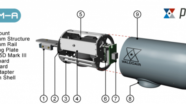
The XCAM is an airborne camera system using commercial off-the-shelf components. Manufactured in the United States, the system includes a 22.3MP DSLR camera, GPS, IMU, flight planning and flight management software, a small dash-mount tablet PC computer, all necessary mounting hardware, accessories and cables as well as a license of Pix4Dmapper software. The 3kg pod attaches externally to an aircraft stepmount or the wing strut of a high-wing aircraft such as Cessna 152, 172, 182, 206 etc. and is used with a small dash-mount tablet PC computer, also part of the system. Already compatible with over 30 aircraft models worldwide, the XCAM can be installed and removed in 30 minutes only.
Finally, WaldoAir’s XCAM system includes a Pix4Dmapper software license to offer users a complete solution for their mapping and modelling needs. Pix4Dmapper is among the leading software for image-based photogrammetry, allowing users to process thousands of aerial and oblique images to create survey-grade accurate orthomosaics, DSMs and point clouds. Pix4Dmapper features a fully automatic workflow and can be used by anyone as it is very intuitive and easy to use, one of the many reasons why it is already heavily adopted by the UAV community.
The XCAM system will provide existing professional photogrammetrists with a solution for surveying small to medium size areas all the while enabling professionals of aerial photography to acquire aerial imagery that allows to produce survey-grade, georeferenced cartography and 3D models.
The XCAM system is being presented for the first time at ASPRS 2014 Annual Conference, which is being held in Louisville, Kentucky, USA from 23 to 28 March. Find WaldoAir’s booth in the UAV section of ASPRS.
Image courtesy: WaldoAir

Value staying current with geomatics?
Stay on the map with our expertly curated newsletters.
We provide educational insights, industry updates, and inspiring stories to help you learn, grow, and reach your full potential in your field. Don't miss out - subscribe today and ensure you're always informed, educated, and inspired.
Choose your newsletter(s)


