Lidar Data Helps Prioritize Flood Risk at Yellowstone
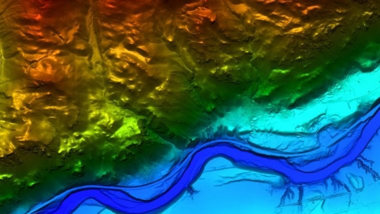
Lidar data collected across Yellowstone and Park County, Montana, was used to aid the response to flooding last month. The flooding of Yellowstone River and rivers in other parts of Montana, Wyoming and Idaho, caused by days of heavy rains and snowmelt in June, was referred to by the U.S. Geological Survey as a “1 in 500-year event.” The flooding destroyed bridges, swept away roads, spurred mudslides, led to the evacuation of more than 10,000 visitors and temporarily closed Yellowstone National Park.
Immediately following the flooding, local GIS officials contacted USGS and Woolpert to procure Lidar data recently collected across Yellowstone and Park County, Montana, to aid in their response. Steven Jay, Park County GIS/IT analyst, said the data, including collections over many remote and densely forested areas, is needed to model the terrain, prioritize areas at a higher risk of flooding and identify areas of erosion.
Elevation Data
Woolpert and USGS responded to this request and delivered Lidar data and imagery within 24 hours, helping accelerate recovery and providing needed resources to help the park reopen. Woolpert vice president John Gerhard said this event and the swift request from Yellowstone officials for current and accurate Lidar data and imagery illustrates their value in emergency response and recovery. He said these collections have been driven by USGS, its 3D Elevation Program and its 3D Hydrography Program.
“USGS has been working to update the National Map to ensure that needed elevation data are routinely collected for multiple applications, especially in times of distress,” Gerhard said. “As our land and seas evolve, these data and other efforts, like the Greater Yellowstone Climate Assessment, provide invaluable resources in our fight against climate change. We will continue to support these efforts in Yellowstone and these key USGS initiatives however we can.”

Value staying current with geomatics?
Stay on the map with our expertly curated newsletters.
We provide educational insights, industry updates, and inspiring stories to help you learn, grow, and reach your full potential in your field. Don't miss out - subscribe today and ensure you're always informed, educated, and inspired.
Choose your newsletter(s)


