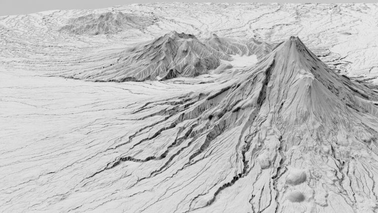
Lidar Survey Unveils Taranaki Region's 3D Landscape
A new, high-tech aerial laser survey project has been completed in the New Zealand region of Taranaki, producing an exact 3D map of the region's land surface. The survey, conducted by Toitu Te Whenua Land Information New Zealand (LINZ) in partnership with the Taranaki Regional Council, will provide valuable data for a variety of uses.
The data is set to be used to generate high-definition 3D maps and models that will be used for applications including environmental management and planning, natural hazard management, and infrastructure and service planning. Additionally, the data will be used to track changes to the coastline and river channels.
Bjorn Johns, LINZ technical leader, Imagery and Elevation, explained that the dataset was two years in the making. “It’s exciting that we now have accurate elevation information, right down to the property scale, for the entire Taranaki region. The new digital elevation data provides certainty to councils and landowners and ensures their terrain modelling is as accurate as possible."
“The Lidar data allows for improved 3D visualization of the land, providing valuable context for planning and mapping. The data is available to anyone via the LINZ Data Service," he added. “As new datasets across the country are completed and contributed to the LINZ National Elevation Programme, the amount of national coverage increases, giving us the best possible picture of New Zealand.”
Invaluable Data for Environment and Livelihoods
“It’s fantastic to see the completion of the Taranaki Regional Council-led project and now we can start using that invaluable data to keep caring for our environment and supporting livelihoods,” said council director-operations Daniel Harrison. “There are a myriad of applications where we and our partners can use this data and it is available to the public as well. The level of detail is incredible and it will be a really useful tool for our staff.”
Funding for the NZ$1m project has come from the Provincial Growth Fund (PGF) via LINZ, with contributions from the Council, New Plymouth District Council, Stratford District Council, South Taranaki District Council and the University of Auckland. Taranaki Regional Council was one of 10 regional councils nationwide given funding from the PGF for regional-scale Lidar mapping projects.
Harrison said the Lidar information will help the district councils in land-use planning and assessing the provision of services, while the University of Auckland is interested in the surveys of the Taranaki Maunga volcanic cone.

Value staying current with geomatics?
Stay on the map with our expertly curated newsletters.
We provide educational insights, industry updates, and inspiring stories to help you learn, grow, and reach your full potential in your field. Don't miss out - subscribe today and ensure you're always informed, educated, and inspired.
Choose your newsletter(s)


