Map of Birmingham's City Life
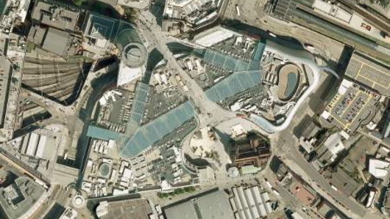
High-resolution aerial photography is being used to create a new map of Birmingham, UK. Supplied by aerial survey specialist Bluesky, the digital imagery will be used to create a royalty-free base map to support Interconnect Birmingham, a project to raise the profile, image and identity of the city. The aim is to create an interactive map which will feature visitor attractions, hotels, green spaces and other places of interest, thus helping to improve the experience of visitors to the city and to support a multi-channel, multi-modal movement and information system.
"One of the key aspects of the Interconnect Birmingham project was an advanced way-finding solution for the urban centre. In order to populate this we needed a royalty-free base map, and aerial photography seemed to offer the optimum starting point for its creation," commented John Maillard, project manager at Birmingham City Council, one of the project partners. "Topographical map layers such as building footprints and roads will be drawn, using the Bluesky imagery as the principle reference, and then styled creating a map that is fit for purpose and truly unique to Birmingham."
The aim of the Interconnect Birmingham project is to improve and integrate the city's image, identity and legibility. It aims to provide a strategic framework to promote quality design solutions and seeks to link existing and proposed transportation, public realm and development projects. Interconnect Birmingham will develop a strategic framework for the delivery of improved streets and spaces in Birmingham's extended city core, accompanied by accurate information to assist way-finding, linked walking and public transport networks, and interpretation. Partners of Interconnect Birmingham include Centro, Marketing Birmingham and Birmingham City Council.
The 8 square kilometres of 10cm resolution imagery form part of a national coverage of highly accurate, up-to-date, orthorectified aerial photography. The images are available off the shelf in a variety of easy-to-use formats including GIS / CAD-ready files.

Value staying current with geomatics?
Stay on the map with our expertly curated newsletters.
We provide educational insights, industry updates, and inspiring stories to help you learn, grow, and reach your full potential in your field. Don't miss out - subscribe today and ensure you're always informed, educated, and inspired.
Choose your newsletter(s)


