Mobile Laser Scanning System for French Railway Mapping Project
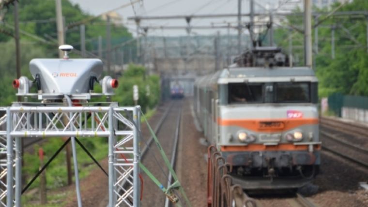
SNCF, the national French railway society, has taken delivery of a RIEGL VMX-450-RAIL intended for the sole purpose of railway mapping. The complete scanning platform can be either installed onto a mounting rack at the rear of a wagon or right into the engine cart. The main tasks of railway mapping include georeferencing railway infrastructure, clearance monitoring in order to detect natural obstacles like vegetation, or determining infrastructural limits for special-load transportation.
Other applications of railway scanning include track and base terrain inspection, as well as supervision and registration of changes in train station structures, such as thresholds between platforms and wagons due to renovation work in train stations. All these different tasks serve to further enhance railway safety.
The operation of a large railway network relies on meticulous organisation – a single change of route or track can cause hours of delays for a large number of scheduled departures.
The RIEGL VMX-450-RAIL is a fully integrated and high-speed mobile laser scanning system, including a lifting frame for crane installation. Technet-rail’s SiRailScan is a 3D data-processing software solution, customised to the specific requirements of SNCF.
At a maximum effective measurement rate of 1.1 million measurements per second, resulting in up to 400 scan-lines per second, the RIEGL VMX-450-RAIL mobile mapping system enables the surveying of large stretches of railway tracks at high speeds, while delivering a dense point cloud containing billions of single measurement points. The effectiveness of the system allows a surveying train to pass between two regularly scheduled trains without causing delays.
SiRailScan is a technet-rail developed cross-platform software for the evaluation and analysis of 3D laser scan data. It can be used to simulate train passages, to determine and localise clearance gauge and to conduct target-actual comparisons of track geometries. It also determines the actual track geometry without any constraints, on the basis of point cloud data, allowing for track's actual position and height to be calculated in a high-precision manner.
The French railway route network is owned by RFF, an independent company of the group, and comprises about 58,000km of route. The network can be considered particularly complex; therefore a continuous, even repeated monitoring and inspection is vital. RIEGL and technet-rail are proud to support these efforts with their mapping solution - VMX-450-RAIL and SiRailScan.

Value staying current with geomatics?
Stay on the map with our expertly curated newsletters.
We provide educational insights, industry updates, and inspiring stories to help you learn, grow, and reach your full potential in your field. Don't miss out - subscribe today and ensure you're always informed, educated, and inspired.
Choose your newsletter(s)


