Mobile Mapping of Amsterdam Ring Road
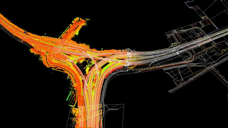
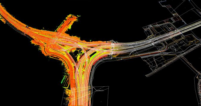
Geomaat has used its mobile mapping system to scan the entire Amsterdam Ring Road, also known as the A10, in the Netherlands. Covering a total distance of 32.3km, the project generated an enormous amount of data, which the company has since processed into usable products for various clients.
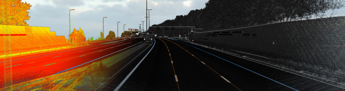
Constructed over 30 years ago, the A10 is one of the busiest motorways in the Netherlands. The stretch of road between Exit S101 and the Coen Tunnel features in the nation’s annual Top 10 of Congestion Hotspots every year. Geomaat has now scanned entire Amsterdam Ring Road, including the Coen Tunnel, for several clients. The company’s mobile mapping system – which comprises a vehicle equipped with GPS, IMU, a photographic camera and two laser scanners – enables the road and surrounding area to be scanned while driving in the regular traffic flow. The system captures two million points per second, resulting in billions of points that are processed into a point cloud. Geomaat subsequently converts that point cloud into information-based products for its clients.
Examples of products
The types of products Geomaat can deliver to its customers based on the point cloud include:
- Digital terrain models (DTMs)
- DTB/KernGIS revisions
- Clearance profiles
- Latitudinal and longitudinal road unevenness
- Superelevation
- C5-IRI values
Major Road Maintenance
Major maintenance work is planned for the A10 and surrounding roads over the coming years, and some of that work is already underway. Geomaat produced a 3D point cloud for Boskalis, Coentunnel Company and Royal Haskoning for various phases of several of these projects. The company subsequently processed the 3D point cloud into a variety of final products before the work started, such as DTMs, asphalt designs, clearance profiles and superelevation. Geomaat has also produced end products for other sections of road for submission as part of the delivery and completion documentation. These include various inspections of the superstructure, DTB/KernGIS and clearance profiles.
BIG-data Vision
Arriving at usable end products for clients requires a huge amount of data to be processed. Geomaat does this based on its ‘BIG-data’ vision. This internal system-based approach enables the company to process of a lot of data in a short period of time. After all, data does not add true value until it is converted into information, which is why Geomaat enhances the raw data with knowledge and information. This ensures that clients receive meaningful insights that they can interpret correctly.
Over the past decade, there has been a significant increase in the power and capacity of computers, thus making point clouds more accessible to everyone. In terms of big data storage, Geomaat has its own data centre and has also developed its own cloud computing system as an online solution. This means that intensive computational tasks such as point cloud processing are spread across all of the company’s computers. Each PC handles a small part of the work, ensuring optimal use of the memory and power of all the computers in the network.
Tools and Software
It is no easy task to convert big data into information. At Geomaat, in line with the company vision – ‘Innovation through automation’ – the process entails the use of internally programmed tools and software created by the company’s own Process and Innovation (PI) department. The result is high quality in a very short space of time. Besides that, the company is currently working on the use of artificial intelligence with its point cloud data.

Value staying current with geomatics?
Stay on the map with our expertly curated newsletters.
We provide educational insights, industry updates, and inspiring stories to help you learn, grow, and reach your full potential in your field. Don't miss out - subscribe today and ensure you're always informed, educated, and inspired.
Choose your newsletter(s)


