
NavVis broadens scope with VLX 3 mapping solution
The NavVis VLX 3 has been unveiled as a groundbreaking advancement in reality capture technology. This is the latest addition to the NavVis VLX product family by the specialist in reality capture and digital factory solutions.
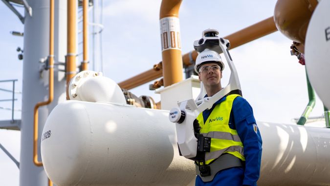
Equipped with two high-end, 32-layer Lidars specifically designed and calibrated for the surveying industry, the NavVis VLX 3 delivers highly detailed and precise point clouds with minimal noise and drift even at long range. Its enhanced SLAM robustness makes it a fitting solution for a wide range of projects, including outdoor endeavours such as topographic and road surveys, as well as complex indoor environments.
While introducing the NavVis VLX 3, NavVis remains committed to providing reliable and accurate solutions to its customers worldwide, enabling them to scan, process and leverage vast amounts of data from various sites in less time. This dedication to advancing the technology allows customers to confidently undertake scanning projects with increased efficiency.
"We're thrilled to be launching NavVis VLX 3 today," says Georg Schroth, CTO and Co-founder at NavVis. "Our team has worked extremely hard to deliver cutting-edge hardware improvements and enhanced scanning features. We're confident it will exceed our customers' expectations and become the go-to tool in their scanning toolbox."
Point clouds and digital twins
The NavVis VLX 3 is presented as the cornerstone of reality capture, offering a nearly unobstructed field of view that ensures comprehensive coverage of any scanned environment. With a scanning rate of 1.2 million points per second, users can rely on accurate and thorough data capture.
Powered by advanced SLAM technology, the NavVis VLX 3 sets itself apart by achieving highly accurate survey results. Its improved algorithm enhances outdoor performance, enabling the capture of building facades at greater distances, thus unlocking new use cases and value-added services for customers. This device empowers users to generate high-quality point clouds of buildings, construction sites, roads, bridges, tunnels and more. Seamlessly integrated with NavVis IVION, the platform for spatial data, the NavVis VLX 3 provides users with the foundation for creating digital twins, enabling smart collaboration and decision-making.
"We’ve always pushed the boundaries of what is possible in dynamic scanning. NavVis VLX 3 is our answer to those who have been putting our technology to the test," says Felix Reinshagen, CEO and co-founder at NavVis. "What was once deemed impossible in the fields of surveying and laser scanning are now realities, and we are delighted to continue driving the industry forward with the launch of our brand-new device."

Value staying current with geomatics?
Stay on the map with our expertly curated newsletters.
We provide educational insights, industry updates, and inspiring stories to help you learn, grow, and reach your full potential in your field. Don't miss out - subscribe today and ensure you're always informed, educated, and inspired.
Choose your newsletter(s)


