New Zealand Engineering Firm Acquires Maptek Spatial Modelling Tools
Gaia Engineers, based in Auckland, New Zealand, has acquired Maptek I-Site Studio and Maptek Eureka for its civil engineering practice. Gaia saw the need for smart automated tools to help interpret geological and geotechnical features from large photogrammetry and Lidar point cloud datasets, which are available in I-Site Studio. Incorporating drilling data to model geology for analysis of structures and failures is streamlined in Eureka.
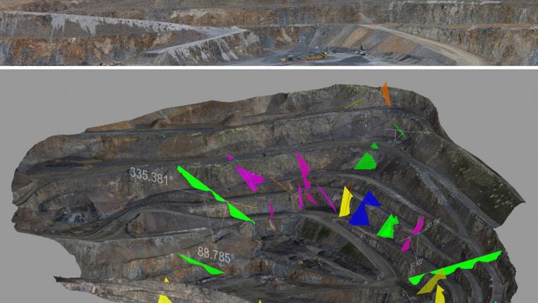
Eureka provides an interactive 3D environment for visualisation and modelling of drilling, geophysical surveys, maps, imagery and GIS data.
Workflows
The Maptek workflows played a critical part in the purchasing decision, said Simon Nelis. technical director of engineering geology at Gaia. In particular they needed a workflow which allowed them to rapidly produce accurate geological models which represent major structures (such as faults and folds) for assessment of global highwall stability, Nelis continued. By combining large point clouds derived from different platforms, Gaia now can produce up-to-date geological models for geotechnical analysis.
Maptek software is the most efficient at handling these large datasets for geological modelling. Its ability to provide digital as-built records of geological conditions during excavation is critical for managing geotechnical risk and for geological and geotechnical input into the BIM model, Nelis added.
Maptek’s advanced visualisation platforms promote efficiency and agility for modelling geology, analysing structures and surfaces, identifying dominant structures and trends and assessing the impact on engineering projects.
Application areas
In the 16 years since Maptek began developing spatial modelling software for working directly on 3D point cloud scan data, the company has maintained an over the horizon view of industry needs, said Maptek global manager for I-Site laser imaging, Jason Richards. With I-Site Studio, Maptek has developed the simplest and smartest software for generating valuable deliverables from laser scan data in wide-ranging application areas. Whether creating 3D CAD objects onscreen or performing advanced geotechnical analysis, engineers can access all of the tools they need in this one package, Richard added.
Built-in workflows respect standard routines, dramatically reducing the time for tasks and allowing more time for analysis and applying results.
Smart algorithms take the pain out of processing. Users can work seamlessly with large 3D datasets onscreen, converting complex 3D point clouds into dynamic 3D models, Richards concludes. Everyone benefits from polished field-to-finish workflows. Consultants get more done and can take on more projects. Customers receive results fast and can effectively communicate with their project stakeholders.

Value staying current with geomatics?
Stay on the map with our expertly curated newsletters.
We provide educational insights, industry updates, and inspiring stories to help you learn, grow, and reach your full potential in your field. Don't miss out - subscribe today and ensure you're always informed, educated, and inspired.
Choose your newsletter(s)


