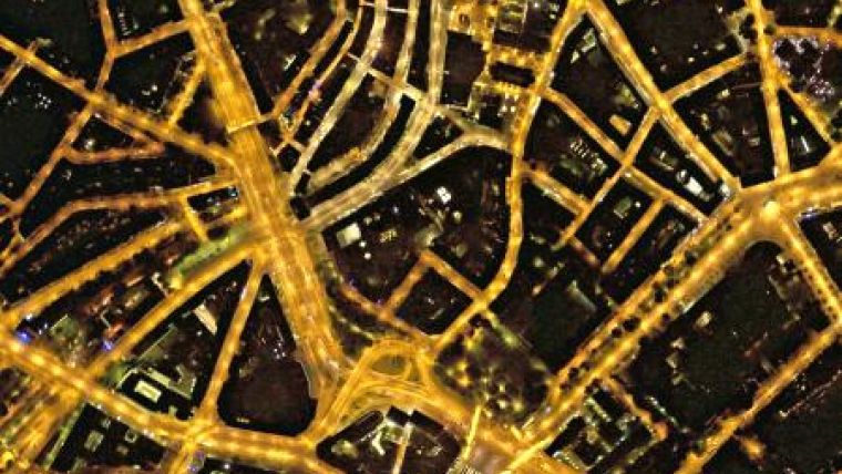
Night Sky Cities Maps from the Air
Bluesky is developing a new service to map Britain's cities and towns at night. Captured using specially developed aerial survey equipment the night sky photomaps will record the location street lights, illuminated road signs and other night-time sources of light. The light emission maps will also provide an accurate base for asset inventories, light pollution assessment and energy optimisation for electricity plants.
Using specially developed technology to capture night orthophotos for the first time, the map accurate images can be used directly in a desktop mapping tool or GIS. Providing additional intelligence for Local Authorities and other organisations that are responsible for lighting infrastructure the maps can be used as an aid for street lighting inventories and condition assessments and to assist with the identification of units for routine maintenance or fault repair.
Additional applications of the night-time survey images are expected to include measurement of illumination for energy consumption evaluations and additional intelligence to support innovative projects to ‘dim' or even switch off selected streetlights in an effort to save money and reduce carbon emissions. Using advanced spatial queries and mapping techniques Bluesky night sky maps can also be used to provide an assessment of light pollution helping to reduce unnecessary illumination and focus lighting infrastructure where it is needed most.
"We believe this is a really valuable addition to our product portfolio," commented Rachel Tidmarsh, Managing Director of Bluesky. "By capturing night orthophotos we can discover more about how we illuminate our cities and towns and, hopefully, help reduce energy consumption and improve the effectiveness of urban lighting projects."
Bluesky already has considerable experience and expertise in the capture and creation of off the shelf night-time aerial imagery as they are the UK's leading provider of thermal photomaps to Local Authorities and partner organisations. Bluesky's thermal survey service measures building roof heat loss levels across an entire city in just one evening together with a bespoke thermal mapping service creating intelligent energy consumption and fuel poverty maps to support energy strategies and local campaigns.

Value staying current with geomatics?
Stay on the map with our expertly curated newsletters.
We provide educational insights, industry updates, and inspiring stories to help you learn, grow, and reach your full potential in your field. Don't miss out - subscribe today and ensure you're always informed, educated, and inspired.
Choose your newsletter(s)


