Pix4D Adds Editing Tool and Subscription Model
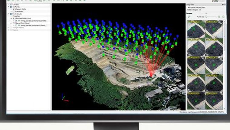
Pix4D, Switzerland, has released Pix4Dmapper, a software package with a fully integrated editing tool providing extended CAD and GIS possibilities. The rayCloud, included in Pix4Dmapper, combines the 3D point cloud with the original images for easy viewing as well as highly accurate semantic annotation and project improvement. Pix4Dmapper now is available both as a one-time-charge licence and on a monthly or yearly subscription basis.
Orthomosaics, DSMs and point clouds generated with Pix4Dmapper achieve survey-grade accuracy from any aerial or oblique imagery, ranging from lightweight compact cameras used on UAVs (including GoPro, multi-spectral cameras and Fisheye lens) to SLR’s and large photogrammetric sensors carried by aircraft. New algorithms allow for more precise results.
While Pix4Dmapper’s fully automatic workflow stays as intuitive and easy to use as prior Pix4D software packages, it gives users full control over all tie points, calibration and results. Using the rayCloud, one can now assess, edit, interpret and improve results directly in the software thanks to the rays connection the 3D point cloud to the original input images. The rayCloud makes it possible to annotate and measure objects with the highest precision, to fully control tie points as well as calibration and even to use any annotations to reprocess projects in order to improve the overall project accuracy (see video below).

Value staying current with geomatics?
Stay on the map with our expertly curated newsletters.
We provide educational insights, industry updates, and inspiring stories to help you learn, grow, and reach your full potential in your field. Don't miss out - subscribe today and ensure you're always informed, educated, and inspired.
Choose your newsletter(s)


