Re-surveying Firms for Levelling after Earthquake
Following a competitive tender process, Land Information New Zealand (LINZ) has appointed Opus, Beca, and CPG to carry out critical re-surveying work in post-quake Canterbury. The three firms will share the significant task of restoring the region\'svertical control network - the system of about 400 survey markers that enable the accurate determination of heights. The work is expected to be completed by June 2011.
Government recently gave LINZ an additional NZD850,000 towards this and other earthquake-related surveys in order to discover how the position of the land has changed - information that is critical as the region's infrastructure is re-established.
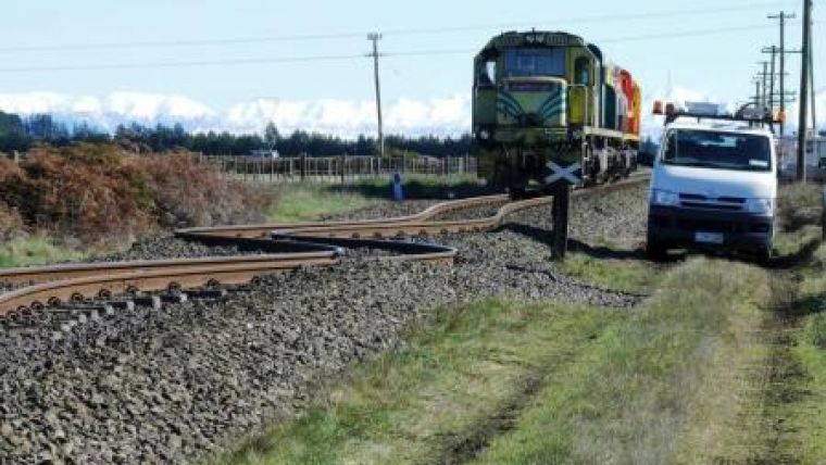
"We have already seen that large areas of Canterbury have experienced movements - both horizontally and vertically - in excess of 10cm, and close to the fault line there have been movements of more than a metre," says Land Information New Zealand's (LINZ) Chief Geodesist, Graeme Blick.
"We know that the flood plains have shifted in Canterbury due to the earthquake. Precise levelling data is required in a very short timeframe, to ensure the region's hazard monitoring abilities are not compromised. Given the flat landscape of Canterbury, this survey work is vitally important to local authorities and property owners."
Graeme says the Canterbury earthquake has opened everyone's eyes to New Zealand's vulnerability to natural disasters, and the widespread property damage and destruction of infrastructure, such as roading, sewer, and storm water systems, has highlighted the importance of the geodetic control network in the re-building phase.
Levelling surveys on this scale are rare - they are currently only done by LINZ following natural disaster like this one. The last one was done after the 1987 Edgecumbe earthquake.
In addition to this precise levelling work, LINZ will be tendering for contracts to restore the horizontal control system. This network of survey markers with coordinates is used for mapping, and is especially significant when it comes to re-establishing property boundaries.
LINZ is the government agency responsible for determining and maintaining the accurate and complete measurements and location of New Zealand's physical features.

Value staying current with geomatics?
Stay on the map with our expertly curated newsletters.
We provide educational insights, industry updates, and inspiring stories to help you learn, grow, and reach your full potential in your field. Don't miss out - subscribe today and ensure you're always informed, educated, and inspired.
Choose your newsletter(s)


