SenSat Raises US$10 Million for Simulated Reality Technology
SenSat – a UK-based geospatial startup company using artificial intelligence to unlock value in the infrastructure industry based on digital representations of real-world locations – has announced a US$10 million Series A funding round, led by Tencent, with participation from Sistema Venture Capital. The new capital will be used to support growth, enabling SenSat to expand its London team of 30 experts by more than threefold over the next year. It will focus on data scientists, mathematicians, software developers and creative problem solvers, as well as driving continued international expansion.
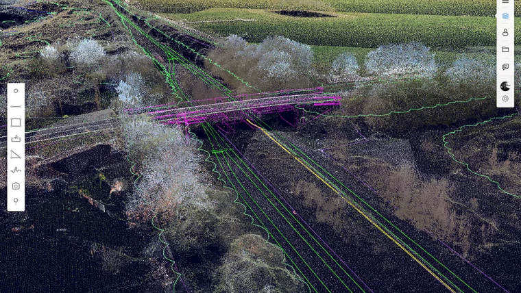
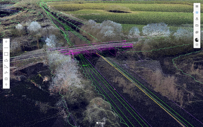
SenSat creates digital representations of real-world locations – otherwise known as digital twins – infusing real-time datasets from a variety of sources. The result is an accurate, digital and up-to-date copy of the real world in a machine-readable format. This enables offline industries, such as infrastructure, to make more informed decisions and accurate analysis, driving vast improvements in safety, cost-efficiency, waste generation, project collaboration and carbon reduction.

Lack of digital impact
US$94 trillion in infrastructure investment is required by 2040 to sustain global growth predictions, yet Infrastructure is one of the least digitized sectors in the global economy, lacking the automation and transparency that has transformed online industries. This lack of digital impact has also meant that much of the industry relies on traditional and inefficient ways of doing business, resulting in a tremendous amount of waste. Combined with the environmental degradation and resource waste linked to unsustainable growth, a particularly compelling case can be made for introducing AI and digital automation to physical sectors.
AI-powered digital twin technology
“SenSat has a simple but profound goal: to build the third platform, an intelligent eco-system that translates the real world into a version understandable to AI. This technology will help us to build a more sustainable future, using the wealth of new insight to help people make better decisions. Our plan is to first focus on perfecting our human-controlled digital twin technology, so we can help to transform the way we deliver Infrastructure,'' explains James Dean, co-founder and CEO of SenSat.
“Using AI-powered digital twin technology to replicate the real world in a digital capacity is the next step towards using data to make better decisions, not only in Infrastructure but in how we impact the world as people. SenSat has scaled rapidly in the past year, and we have big plans for this first major round of investment, adding to our world-class AI expertise, and enabling fresh partnerships with innovators in a range of different fields. With Tencent, we share similar ambitions about the impact of enterprise internet on laggard industries and how that can lead to us operating our world more sustainably.”
Real world data
At the heart of SenSat is Mapp, which allows Infrastructure companies to interact with their workplaces digitally for the first time by allowing digital automation to help them make better decisions with real world data. Despite only launching in 2018, the start-up is already transforming the industry, with Mapp providing major value to more than 30 international Infrastructure companies. As part of a project with Murphy Group for the National Grid, SenSat digitized a 52km underground transmission line as a part of the Triton Knoll offshore wind farm project, resulting in reducing time on site by 200%, as well as vastly reducing the impact on local wildlife thanks to less invasive methods. Most recently, SenSat worked with Berkeley homes, recreating the physical environment digitally for the development of 10,000 new homes. Their assimilation of thousands of separate data points into a single view, meant that Berkeley were able to accelerate their design and decision-making process by 8 months, whilst also providing a powerful tool for future public consultation.

Value staying current with geomatics?
Stay on the map with our expertly curated newsletters.
We provide educational insights, industry updates, and inspiring stories to help you learn, grow, and reach your full potential in your field. Don't miss out - subscribe today and ensure you're always informed, educated, and inspired.
Choose your newsletter(s)


