Skyborne solutions for enhanced Pacific flood monitoring in Fiji
Flash floods pose a significant threat to communities in Fiji and the broader Pacific region. To address this pressing challenge and develop an interactive flood monitoring solution, an aerial Lidar survey was conducted.
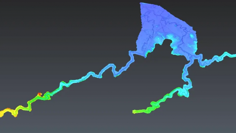
This initiative, led by Kahuto Pacific in collaboration with the Pacific Community-SPC, aimed to create a digital elevation model (DEM) for flood modeling in Fiji's Penang River catchment (Rakiraki). The project is a vital part of the 'Hydrology support for flash flood early warning systems' programme, funded by the Australian Water Partnership (AWP). Its primary focus is on providing technical hydrological assistance to Fiji, Samoa, Solomon Islands and Vanuatu, with the overarching goal of strengthening flash flood early warning systems.
Enhancing climate resilience
The unique topography of Fiji, encompassing both mountainous regions and low-lying coastal areas, coupled with the influence of El Niña weather patterns, can result in heavy rainfall triggering flash floods in low-lying regions. The project's ultimate aim is to enhance climate resilience and strengthen disaster risk reduction (DRR) systems across Pacific Island countries through improved hydrological capacity and more robust flood early warning mechanisms.
Within this context, SPC Hydrologists required a digital elevation model (DEM) derived from aerial Lidar to facilitate flood modelling in Rakiraki's Penang Catchment, Fiji, aimed at bolstering early warning flood systems. The undertaking involved utilizing a DJI M300 drone equipped with an R2A Livox Lidar sensor, allowing for the capture of 600 hectares of aerial Lidar data. The local team based in Fiji, in conjunction with Kahuto, meticulously coordinated control survey and flight plan details to ensure optimal point density capture in an efficient manner. Prior to the aerial Lidar flights, a ground control survey was carried out by registered surveyors, Wood and Jepsen Consultants.
The initiative faced significant challenges, including commencing the project during the peak of the wet season, leading to considerable delays in data acquisition. Additionally, the scale of the endeavour required numerous flights to achieve the desired point density for comprehensive site coverage. Through these concerted efforts, the project aims to create a dynamic flood monitoring solution that empowers communities to stay vigilant and responsive in the face of flash flood hazards.


Value staying current with geomatics?
Stay on the map with our expertly curated newsletters.
We provide educational insights, industry updates, and inspiring stories to help you learn, grow, and reach your full potential in your field. Don't miss out - subscribe today and ensure you're always informed, educated, and inspired.
Choose your newsletter(s)


