Using UAV-Lidar for Operational Forest Management
A new case study from Routescene demonstrates the value of UAV-Lidar point cloud data for operational forest management. Traditionally, gathering metrics and information for forest management has been undertaken using airborne photogrammetry or by manually walking the site. More recently, airborne Lidar has been recognized as a useful tool and drone-derived Lidar data is now proving its significant worth to monitor and manage the health and value of a forest.
Typical metrics and information required to manage forests include identifying individual tree crowns; canopy base height (CBH) which is the average height from the ground to the underside of the canopy; canopy bulk density (CBD) which is the canopy size of a plot, stand or group of trees; and canopy cover which is the proportion of the forest floor covered by the vertical projection of the tree crowns. With such data forest researchers and managers can calculate canopy fuel estimations which can be used in fire modelling to prevent and manage fires, assess the mix of species within forests, and prepare carbon stock estimations.
Measurements over time
Investment in forestry is a long-term strategy both for environmental and commercial purposes. The assessment of structural changes across a forest through time is an important activity to ensure the continued vitality, and hence value, of the asset. Detecting changes in the canopy, for example defoliation which can be associated with disease, can be used to identify and limit outbreaks of pests and infection. Such monitoring over time also informs growth rates, windthrow, deforestation and post-harvesting residue quantification.
Individual tree level
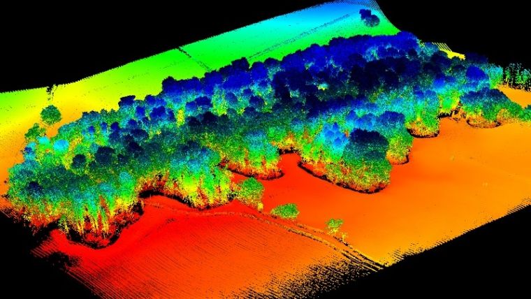
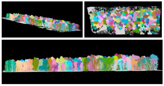
This case study, performed across a 44,256-square-metre wooded site in Barnsley, UK, proved the advantages of using high-density UAV-Lidar data. The highly detailed dataset contained a total of 8,912,679 points enabling algorithms to be applied directly to the point cloud; this allowed the team to profile the site to individual tree level and extract pertinent metrics easily. In comparison, with lower-density datasets individual tree profiling is typically extracted indirectly in a two-step process and less accurately. Profiling to an individual tree level can be particularly useful in variable heterogeneous forest environments such as this site, to establish the structural complexity, its resilience and adaptability, to inform the management required.
Informing future forest management
In addition, the sheer size of forestry sites can make projects labour intensive, complicated further by dangerous or inaccessible terrain. These challenges can be overcome by using UAV-Lidar to capture data in discrete areas rather than the whole forest. This is especially useful for homogenous plantations when the stand surveyed is sufficiently representative of the whole, enabling the data to be used to inform the majority of management objectives such as growth monitoring and harvesting planning. In conclusion, the digital terrain models and metrics produced by this survey will inform future conservation and land management.
More information about this case study can be found here.


Value staying current with geomatics?
Stay on the map with our expertly curated newsletters.
We provide educational insights, industry updates, and inspiring stories to help you learn, grow, and reach your full potential in your field. Don't miss out - subscribe today and ensure you're always informed, educated, and inspired.
Choose your newsletter(s)


