Virtual Surveyor unveils photogrammetry app in smart drone survey software upgrade
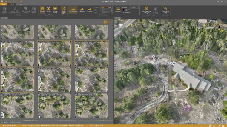
Virtual Surveyor has added drone photogrammetry capabilities to the latest release of its popular Virtual Surveyor smart drone surveying software. The new Terrain Creator app photogrammetrically processes drone photos to generate survey-grade terrains which then transfer seamlessly into the traditional Virtual Surveyor workspace where the real survey work can be performed.
“Virtual Surveyor software is now two desktop apps in one subscription package that create a seamless end-to-end drone survey workflow to save time and money,” said Tom Op ‘t Eyndt, Virtual Surveyor CEO. “Terrain Creator removes complexity from the drone photogrammetry process, offering a visual and intuitive application to produce an orthomosaic and digital surface model (DSM) from drone photos.”
Fully integrated workflow
Virtual Surveyor software was originally developed to bridge the gap between drone photogrammetric processing applications and engineering design packages. Until this new release, users had to rely on third-party software to generate elevation models and an orthomosaic that could then be worked on with the Virtual Surveyor toolset to derive the 3D topographic information needed by engineers for construction, surface mining, and excavation projects.
“Drone surveyors no longer have to spend money on a third-party photogrammetry package to convert their drone photos into an orthomosaic and DSMs,” said Op ‘t Eyndt. “It just comes with our package, and the fully integrated workflow eliminates the time spent porting photogrammetry products from another package into Virtual Surveyor.”
Once the survey-grade terrains flow from the Terrain Creator into the Virtual Surveyor desktop app, users access the familiar interactive virtual environment and robust toolsets to generate CAD models, create cut-and-fill maps and calculations, or calculate volume reports – just as they always have in Virtual Surveyor.
Current subscribers to Virtual Surveyor Ridge and Peak editions will see their software updated automatically to Version 9.0 with Terrain Creator. A flexible licensing setup will allow two users within a subscribing organization to use the Terrain Creator and Virtual Surveyor applications simultaneously from different computers.

Value staying current with geomatics?
Stay on the map with our expertly curated newsletters.
We provide educational insights, industry updates, and inspiring stories to help you learn, grow, and reach your full potential in your field. Don't miss out - subscribe today and ensure you're always informed, educated, and inspired.
Choose your newsletter(s)


