Wingtra debuts pioneering Lidar drone solution
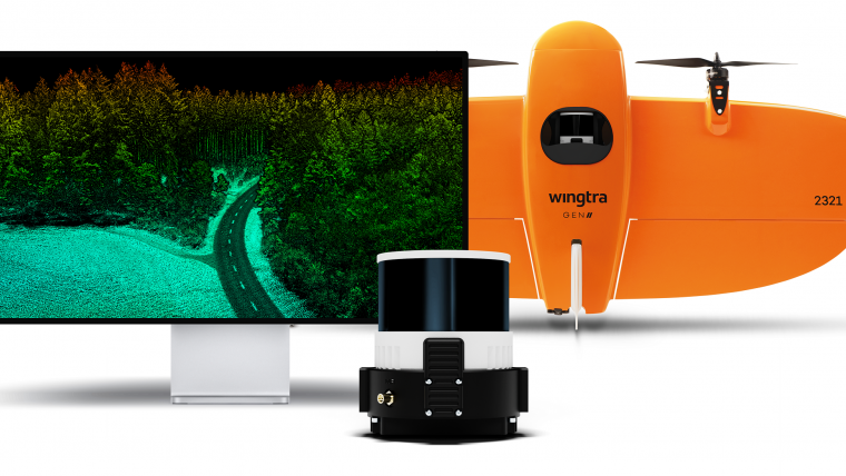
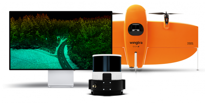
Wingtra has unveiled its innovative Lidar-drone solution. The new Lidar payload is designed to seamlessly integrate the efficiency, ease of operation, and high accuracy of the WingtraOne GEN II drones with an advanced Wingtra-engineered Lidar sensor, offering notable advancements in the industry. Wingtra is a prominent player in drone technology.
The Swiss-based company’s solution is already gaining traction worldwide, with customers in various sectors relying on the WingtraOne GEN II for efficient, safe and frequent mapping for photogrammetric analysis of worksites. The addition of the meticulously engineered Lidar payload offers an all-encompassing solution, covering everything from the initial discovery phase through to project implementation and infrastructure maintenance.
By integrating a top-tier Hesai scanner, Inertial Labs IMU and NovAtel GNSS, Wingtra Lidar dramatically reduces the need for time-consuming post-processing strip alignment, delivering precise terrain information immediately from each efficient flight.
Promising first user responses
Julian Mackern, product manager at Wingtra, expressed his enthusiasm: "We’re already seeing our first customers comment how surprisingly easy it is to set up, fly and generate a high-quality point cloud. And as always, we keep our promise with the data: high-precision, reliable and repeatable."
Carlos Femmer, director of data acquisition at HDR, an internationally renowned American design and engineering firm, shared his insights from testing the Wingtra Lidar payload: "We're seeing [USGS topographical] quality level zero results on hard surfaces, which are quality results. We were able to test the horizontal and vertical strip alignment quality. We looked at both vegetated areas and non-vegetated areas, and it’s very clean, it aligns well. There's minimal noise as compared to other Lidar sensors in this price range and it delivers exceptional overall precision."
Notably, Wingtra Lidar is also developed to reduce field time, requiring no calibration and initializing in just one minute. The intuitive Wingtra Lidar app and automated experience quickly build confidence even for those new to Lidar data capture, saving at least an hour per survey compared to other systems in its class.
Leo Liu, director of mapping solutions at Inertial Labs, praised the efficiency of the system: "Wingtra Lidar capture and processing is super-efficient. Technically, if you have everything structured, it’s literally one click and it’s done to get you to that point cloud. In terms of drone Lidar capture, the goal is that it has to get cheaper and simpler to use.”
Wingtra Lidar offers 3cm vertical accuracy, verified by lead customers as top of the range from a 60m (200ft) flight height. Point density is top of its class, and the WingtraOne GEN II’s design and automated flight pattern ensure consistency across different pilots.
For more information, visit Geo-matching.

Value staying current with geomatics?
Stay on the map with our expertly curated newsletters.
We provide educational insights, industry updates, and inspiring stories to help you learn, grow, and reach your full potential in your field. Don't miss out - subscribe today and ensure you're always informed, educated, and inspired.
Choose your newsletter(s)


