The Evolution of FLEPOS 3.0
A continuously operating reference station (CORS) provides GNSS data to support very accurate 3D positioning and additional geophysical applications. Flemish Positioning Services (FLEPOS) is the real-...
Positioning is the accurate determination of the location of an object in space, relative to a framework or datum. In geographic / hydrographic information positioning is always present to determine the location of whatever we are measuring.
Depending on the type of application the framework can be global or local. When used globally techniques such as GNSS are used and the framework is defined by geodetical coordinate reference systems. Local positioning can be done on a jobsite such as in construction and engineering with total station but in for indoor navigation.
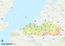
A continuously operating reference station (CORS) provides GNSS data to support very accurate 3D positioning and additional geophysical applications. Flemish Positioning Services (FLEPOS) is the real-...
These are exciting times in satellite navigation. Selective availability for GPS switch-off has fuelled use of satellite navigation technology in professional and consumer applications and new signals...
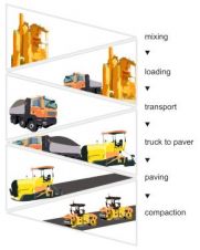
The full feature is online at http://member.gim-international.com/. Please subscribe for free using the Subscribe button in the left hand column. Any sub-optimal operation within the asphalt construct...
GNSS provides accurate positional information with relatively low integrity, while INS offers position and attitude information subject to drift but with relatively high integrity. Integrating the two...

From entrepreneurs to incorporation to becoming publicly traded and now ISO certified, Hemisphere GPS has evolved into a major player in the design and manufacture of precision GPS products. With corp...
GPS receivers, digital compasses (magnetometers) and tilt sensors (accelerometers) are increasingly implemented in state-of-the-art smartphones such as the iPhone and various Android Phones. The resul...
The BeiDou Navigation Satellite System (BDS) officially started providing its service to the Asia-Pacific region on 27 December 2012. Its regional service capability is equal to that of GPS. As the th...
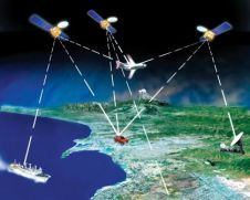
The market for Global Navigation Satellite Systems (GNSS) has never looked so buoyant. Are we in the midst of a revolution or simply witnessing evolution pre-planned and destined to run its course? Tw...
This month we bring you an extended interview with engineer Pedro Pedreira, executive director of the European Global Navigation Satellite System Supervisory Authority (GSA)since July 2005, the body c...

Shanghai-based CHC Navigation Technology Ltd. designs, manufactures and markets a wide range of professional GPS/GNSS solutions for the survey, construction and GIS markets. The past decade has seen t...
In contrast to that of 2005, this product survey on GNSS receivers does not reveal any remarkable technological break-throughs. Manufacturers are increasingly producing systems able to receive Navstar...
The collection of Ground Control Points (GCP) for block adjustment is a costly and time-consuming operation. Onboard GPS enables a reduction in the number of GCPs without loss of accuracy. The authors...
GPS and GLONASS: two operational Global Navigation Satellite Systems (GNSS), one owned by US and the other by Russia - <i>I know they give me positions; I know they enable me to navigate. But why is G...
During the last decade, GNSS (Global Navigation Satellite System) technologies experienced an accelerated growth, both in terms of quantity in use and quality. The accuracy achieved by technology prov...
This site uses cookies. By continuing to use this website, you agree to our Cookies Policy. Agree