What’s new in Global Mapper Pro v25?
Blue Marble Geographic’s flagship software, Global Mapper Pro, is an all-in-one GIS package for analysing and processing vector, terrain, image and point cloud data. Compatible with over 380 different file...

Blue Marble Geographic’s flagship software, Global Mapper Pro, is an all-in-one GIS package for analysing and processing vector, terrain, image and point cloud data. Compatible with over 380 different file...
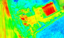
Topodrone has recently unveiled a cutting-edge drone thermal mapping solution: the Topodrone PT61 camera, designed to conduct detailed surveys and generate thermal orthomosaic maps, facilitating the creation of accurate 3D...
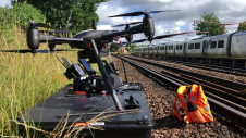
Plowman Craven has introduced Vogel Freedom, a UAV survey system designed for rail infrastructure surveying. Vogel Freedom is a survey-grade solution that surveys tracks without physical access. A novelty in...
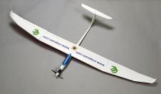
A team from Greece studied the use of aerial imagery to achieve wide coverage of a predefined geometrical area of interest in a project to explore the contribution of UAVs...

Both vertical and oblique aerial images have their own advantages, making them valuable in different reality mapping applications. So how can you choose between the two? This comparison will help...
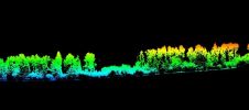
Topodrone has announced the integration of its Lidar Prime scanner with the aOrion Heli-E UAV enabled by Velodyne’s Alpha Prime sensor. This is aimed at bridging the gap in UAV-based...

In a high-flying endeavour spanning over six decades, the UK’s National Grid's fleet of advanced helicopters have been diligently patrolling pylons and power lines, ensuring the health and reliability of...
The most new activity in remote sensing is at the moment found in the UAV and UAS sector (Unmanned Aerial Vehicle / System). There are hundreds of companies, institutions and...
This site uses cookies. By continuing to use this website, you agree to our Cookies Policy. Agree