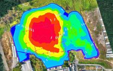
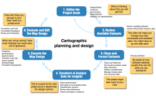
Found 368 results
Sort by

Cable inspections the uncrewed way

XOCEAN has completed 35 cable inspection surveys using a combination of uncrewed surface vessels (USVs) and uncrewed aerial vehicles (UAVs) between the Scottish mainland and Western Isles. There was a...

Read more

Vegetation Mapping Using Multispectral UAV Images

DJI recently introduced the P4 multispectral, a high-precision unmanned aerial vehicle (UAV or ‘drone’) which exploits the integration of multispectral cameras to facilitate agricultural and environmental monitoring applications. Therefore, imagery...

Read more

Mapping Africa's Seafloor

A two-part webinar series entitled ‘Mapping the Seafloor around Africa’ was jointly organized by the IOC-UNESCO Sub-Commission for Africa and the Adjacent Island States (IOCAFRICA) and the Nippon Foundation-GEBCO Seabed...

Read more