The One and Only
The need for accurate and detailed geo-information is tremendous and compelling. This is a worldwide trend, apparent in all countries. Continual migration from rural areas to urban fringes creates...
The need for accurate and detailed geo-information is tremendous and compelling. This is a worldwide trend, apparent in all countries. Continual migration from rural areas to urban fringes creates...
With over 580 registered delegates from 32 countries, forty international exhibitors and nearly a hundred abstracts submitted, the eighth annual International Lidar Mapping Forum(ILMF) reflected the growing importance of Lidar...

Applanix (Canada) has introduced POSPac AIR Version 4.4, a post-processing software used to extend the accuracy potential of the POS AV system. Designed to maximise data quality and optimise workflow...
NovAtel Inc. (Canada) has released its Version 7.80 GrafNav/GrafNetTM, GrafNav/GrafNet Static, GrafNav Lite and GrafMov post-processing software. This latest software release includes significant advancements such as Precise Point Positioning (PPP),...
Trimble (CA, USA) has introduced the GPS Pathfinder ProXRT receiver, a flexible GNSS receiver for GIS data collection and mapping. The receiver combines a high- performance GPS receiver with Trimble...
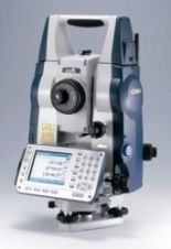
Sokkia (Japan) has released the new total station SET X featuring the highest environmental protection rating for Windows CE- based total stations, onboard SDR software and a flexible, long-life battery...
ASTEC GmbH, Germany, is a private company specialising in airborne data collection and derived products. In late 2006 ASTEC GmbH took over business, equipment and staff from Terra Digital GmbH...
More than five hundred exhibitors from 32 countries are due to put in an appearance at Intergeo 2008, presenting a comprehensive overview of the geo(infor)matics business today. Covering a wide...
The Norwegian company Terratec has introduced software capable of accurate positioning based on post-processing of GPS-observations, without the use of reference stations or DGPS services. Typical accuracy for kinematic applications...
3D Laser Mapping (United Kingdom) has developed a mining industry version of its StreetMapper system. MineMapper uses the latest mobile laser scanning technology combined with high precision positioning systems to...
This site uses cookies. By continuing to use this website, you agree to our Cookies Policy. Agree