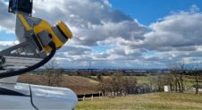
The application of visual positioning technology to geological mapping is of great significance given its current widespread use and huge potential in multiple industries. It is a significant exploration for combining GNSS, IMU, and cameras for a surveying and mapping job. Visual positioning technology can break through the bottlenecks of traditional mapping scenarios. It makes geological mapping more accurate, efficient, and diverse. The vRTK is the first GNSS receiver with dual cameras. Let's see what surprises it will bring to us in the land survey! Visual Positioning Technology is a Major Breakthrough in GNSS Receiver Development The GNSS Receiver has evolved over the years. Through continuous product improvements, a highly integrated RTK receiver with inertial...