Human Capacity - Building for the Future
Over the last decade many cadastral agencies have made significant investments in hardware, software and in upgrading their data. New land information systems have been created and the story has...
Over the last decade many cadastral agencies have made significant investments in hardware, software and in upgrading their data. New land information systems have been created and the story has...

As we enter the era of smart manufacturing, the reliability of data is growing in significance and data standardization is becoming increasingly important. According to JP Kelly, associate director and...
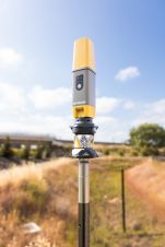
Topcon Positioning Systems has presented the latest addition to its HiPer family of global navigation satellite system (GNSS) receivers. The HiPer CR is a compact and lightweight GNSS receiver designed...

Sven Cowan is NV5 Geospatial’s Programme Manager for Canada. He has over 20 years of experience in customer-facing positions within the geospatial information industry and has worked for multiple geospatial...

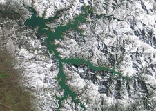
A topobathymetric Lidar survey was conducted to support flood preparedness in Canada. Which techniques achieved exceptional precision, and what were the logistical challenges? Find out more in this article. As...

In accordance with the statutory mission and activities of the International Society for Photogrammetry and Remote Sensing (ISPRS), the society shall provide funds to support educational and capacity-building initiatives. These...
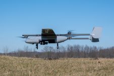
In a new strategic partnership, Inertial Labs' RESEPI Payload Lidar technology will be integrated into E38's advanced E455 drone platform. This collaboration marks a significant milestone in the utilization of...
PlanetScope is now accessible on Google Cloud Marketplace. This availability of Planet's flagship satellite imaging product contributes to the company's mission to democratize access to near-daily satellite imagery, enabling organizations...

The AlphaUni 20 (AU20) Lidar system represents a new era in cost-effective, multi-platform mobile mapping solutions, according to CHC Navigation (CHCNav), a global leader in precision mapping, positioning and navigation...

Linda Foster oversees Esri’s worldwide strategic vision for land administration and surveying. With 20 years of experience working in the land and resource industry, she is a registered professional land...
This site uses cookies. By continuing to use this website, you agree to our Cookies Policy. Agree