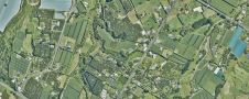
LINZ takes New Zealand to the cloud with 20TB aerial data
Land Information New Zealand has made 20TB of aerial imagery available for free for the first time in a cloud-optimized format on Amazon Web Services (AWS), making it easier and...
Land Information New Zealand has made 20TB of aerial imagery available for free for the first time in a cloud-optimized format on Amazon Web Services (AWS), making it easier and...

Over the past 20 years, various initiatives have been launched reflecting the importance of cadastral data for land management and spatial development. But how have these initiatives enhanced the possibility...

Maxar Intelligence has been awarded a contract to supply the National Geospatial-Intelligence Agency (NGA) with a Precision3D Data Suite bundle. This comprehensive package covers an extensive area of 160,000 square...
The Hyogo Framework for Action (HFA) calls for Disaster Risk Reduction (DRR) to be made a national priority with a strong institutional basis for implementation. The challenges posed by this...
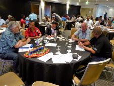
The FIG Asia Pacific Capacity Development Network (AP CDN), comprises of a group of dedicated individuals from our Commissions, the corporate sector, academic networks, and our sister organizations. Our main...

Jonathan Arthur Quaye-Ballard is a professor and head of the Department of Geomatic Engineering at KNUST, where he has worked for the past 20 years. He also holds a BSc...

Naa Lamkai Quaye-Ballard has worked as a consulting geodetic engineer in Ghana for over 15 years. She is currently a researcher with the Council for Scientific and Industrial Research (CSIR)...

Incorporating smart methodologies in cadastral surveying is improving the land acquisition system in Ghana. Traditional cadastral surveying is time-consuming and, if not planned out well, could cost a fortune to...
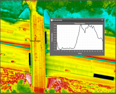
NV5 Geospatial's thermal infrared (TIR) solutions for transportation infrastructure challenges are currently being implemented in projects to analyse concrete bridges in the USA's Midwest. NV5 Geospatial, a leading geospatial data...
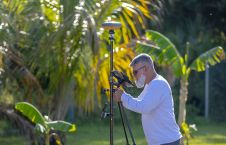
Topcon Positioning Systems has recently unveiled several initiatives in line with its ongoing commitment to sustainability. A new global team dedicated to sustainability and corporate social responsibility (CSR) has been...
This site uses cookies. By continuing to use this website, you agree to our Cookies Policy. Agree