Terra International Surveys Ltd.

Synspective has partnered with Insight Terra to offer a new space-based monitoring solution for the mining industry. The solution combines satellite and Earth observation data with ground sensors to monitor...
Land Information New Zealand has made 20TB of aerial imagery available for free for the first time in a cloud-optimized format on Amazon Web Services (AWS), making it easier and...
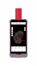
ComNav Technology has introduced its new handheld P6H. This advanced and rugged device is tailor-made for GIS data collection and outdoor operations. Featuring a GNSS high-precision positioning module, rugged IP67-rated...

Over the past 20 years, various initiatives have been launched reflecting the importance of cadastral data for land management and spatial development. But how have these initiatives enhanced the possibility...

Eternix has announced the release of Blaze Terra 5.0, the newest version of its flagship product, now including fully fledged symbolisation. Blaze Terra users now have a great variety of...
Blue Marble Geographics has released GeoCore 2.0, the conversion developer tool kit for geospatial data. The updated version of GeoCore includes the latest versions of GeoTransform, GeoCalc, and GeoTranslate software...
Topcon has announced the release of ScanMaster 2.0 software which is faster and more powerful than previous versions. This new software saves time and increases the productivity on every job,...
Navigation is a daily activity for many as they move from place to place. With increasing complexity in transportation networks has come a rising demand for navigational assistance. Over the...
We all know about the rapid evolution in world mapping. While mapping was long the domain of skilled mapmakers, nowadays it is increasingly in the hands of the lay public,...
This site uses cookies. By continuing to use this website, you agree to our Cookies Policy. Agree