Who should define DEM quality and how?
The diversity of relief mapping methods and the existence of large elevation databases intended for multiple users raises the issue of DEM quality. Digital elevation model (DEM) accuracy is commonly...
The diversity of relief mapping methods and the existence of large elevation databases intended for multiple users raises the issue of DEM quality. Digital elevation model (DEM) accuracy is commonly...
A recent forestry-based case study demonstrates the value of remote sensing techniques such as UAV-Lidar for identifying diseased or damaged trees and overgrown vegetation close to powerlines to prevent outages...
Surveying and mapping are an important foundation for the development of a national economy. An accurate understanding of the spatial configuration of a territory and information about its attributes is...
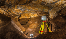
TLS and SfM photogrammetry have been used for the geodetic surveying and 3D mapping of the Ochtiná Aragonite Cave in Slovakia. This world-famous karst landscape of significant geological, geomorphological and...
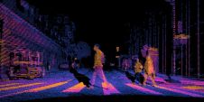
European Association of Aerial Surveying Industries Planning, disaster management, and safety challenges inherent in complex urban environments call for innovative solutions. Researchers around the world are progressing the field, drawing upon cutting-edge work using approaches such...
The mission: capturing 21 quarries in 60 days. Squeezed into that timeframe were planning and performing the UAV photogrammetry flights, editing the RAW images, processing the data, extracting the topography using Virtual Surveyor, and production of the orthophotos, Digital Surface Model (DSM), Digital Terrain Model (DTM) and contour maps for each site. The main client, a government institute, needed highly precise and reliable 3D models and maps fast, as well as data their engineers could work with in a CAD environment. “There was a lot of pressure because of the short timeline”, said Nuno Santos, owner and CEO of Aerisurvey, a Mangualde, Portugal-based company specialized in high-precision UAV surveying. Mapping 21 Quarries in 60 Days The mission was to capture 21 quarries in 60 days. Squeezed into that timeframe were planning and performing the UAV photogrammetry flights, editing the...
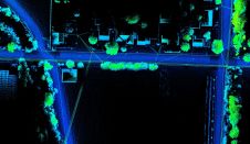
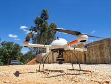
Both vehicle-based and UAV-based Lidar systems from Routescene have been used in a survey to prepare for the replacement of aging power lines in Oliver, British Columbia, Canada. Electricity distribution...
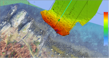
XOCEAN has completed 35 cable inspection surveys using a combination of uncrewed surface vessels (USVs) and uncrewed aerial vehicles (UAVs) between the Scottish mainland and Western Isles. There was a...

As the demand for elevation data continues to rise, it is important that users match the level of reliability, accuracy and resolution of the data to their specific application to...
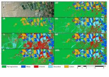
A recent study created crop type maps using Lidar, Sentinel-2 and aerial data along with several machine learning classification algorithms for differentiating four crop types in an intensively cultivated area....
This site uses cookies. By continuing to use this website, you agree to our Cookies Policy. Agree