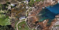
Found 307 results
Sort by

UAS Lidar survey over an ancient Pueblo site

Archaeologists have been studying the Sand Canyon Pueblo in Colorado, USA, for decades. Today, painstaking traditional mapping and visualizations no longer suffice for detailed studies. A survey combining an unmanned...

Read more

UK is a Leader in Heritage Mapping

The mapping of historical cultural features, which we will call heritage mapping, is mainly based on photogrammetric methods. Mapping for this purpose has been going on for many years using...

Read more

Recent Developments in Airborne Lidar

The arrival of airborne Lidar, also referred to as airborne laser scanning (ALS), has revolutionized area-wide 3D data acquisition of topography, bathymetry, vegetation, buildings and infrastructure. This article presents an...

Read more