JOUAV unveils advanced airborne Lidar sensor
JOUAV has released the JoLiDAR-1000 Lidar sensor designed specifically for uncrewed aerial vehicles (UAVs or ‘drones’) as the latest addition to its array of high-performance Lidar sensors for use in...

JOUAV has released the JoLiDAR-1000 Lidar sensor designed specifically for uncrewed aerial vehicles (UAVs or ‘drones’) as the latest addition to its array of high-performance Lidar sensors for use in...

Mosaic has partnered with Movella aimed at redefining precision and efficiency in mapping and 3D reconstruction projects. Mosaic is specialized in mobile mapping camera systems, while Movella is a renowned...

Sven Cowan is NV5 Geospatial’s Programme Manager for Canada. He has over 20 years of experience in customer-facing positions within the geospatial information industry and has worked for multiple geospatial...

Visitor registration is now open for GEO Business, the UK's largest geospatial event. The free-to-attend expo, tailored for geospatial professionals seeking to harness the potential of location intelligence, will return...

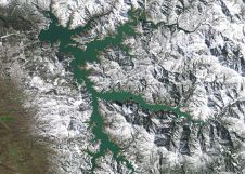
A topobathymetric Lidar survey was conducted to support flood preparedness in Canada. Which techniques achieved exceptional precision, and what were the logistical challenges? Find out more in this article. As...

Maxar Intelligence has been awarded a contract to supply the National Geospatial-Intelligence Agency (NGA) with a Precision3D Data Suite bundle. This comprehensive package covers an extensive area of 160,000 square...
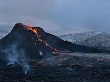
The Icelandic authorities have commissioned Acecore to map the extent and aftermath of the Eldvörp-Svartsengi volcanic system eruption using its high-end drone solutions. Grindavík, a fishing village on the Reykjanes...
PlanetScope is now accessible on Google Cloud Marketplace. This availability of Planet's flagship satellite imaging product contributes to the company's mission to democratize access to near-daily satellite imagery, enabling organizations...
At Geo Week 2024 in Denver, Maptek unveiled its latest innovation: Maptek GeoSpatial Manager. This groundbreaking solution simplifies and streamlines workflows, revolutionizing how mining and civil engineering projects manage data...
This site uses cookies. By continuing to use this website, you agree to our Cookies Policy. Agree