A mission to add Guernsey to Google Street View
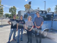
A man who received a 360-degree camera as a gift has taken it upon himself to incorporate his neighbourhood in Guernsey into the Google Street View online map, according to...

A man who received a 360-degree camera as a gift has taken it upon himself to incorporate his neighbourhood in Guernsey into the Google Street View online map, according to...
In this Q&A, we asked Trimble’s Jeff Turgeon to share his insights into the current state of the sector and his expectations for the future. Looking at terrestrial laser scanners,...

Dr Ferdinand Vettermann holds a PhD in Geoinformatics and is a cognitive solutions engineer at the German geointelligence company Deeeper.technology. As an expert in geoinformatics, he is responsible for linking...
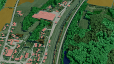
Innovative methodologies based on artificial intelligence (AI) are lowering the barriers and democratizing the use of 3D digital twins in the geospatial industry. Digital twins are revolutionizing the geospatial industry,...
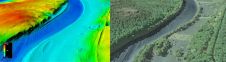
The US Geological Survey (USGS) and Dewberry have jointly released a new topobathymetric Lidar dataset for the Potomac River, extending from the Potomac Highlands in West Virginia to the Chesapeake...
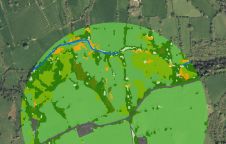
The UK’s Peak District National Park Authority is pioneering the use of artificial intelligence (AI) to automate the production of highly detailed land cover maps, in a project in partnership...
It can still be difficult to achieve centimetre-level accuracy in mobile mapping, especially in GNSS-denied or challenging areas such as in deep urban canyons, under foliage or through tunnels. However,...

Recently unveiled by Vexcel Imaging, the groundbreaking UltraCam Dragon 4.1 represents one of the market's most advanced, progressively designed and seamlessly integrated hybrid aerial mapping systems. Tailored for high-resolution mapping...

Intergeo 2023 was an electrifying three-day event in Berlin, transforming the city into the global geospatial capital. From 10-12 October, professionals from across the globe convened for the world’s premier...
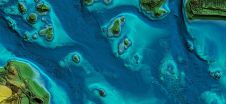
In this article, we examine the evolving landscape of bathymetry with insights from Anders Ekelund, vice president of airborne bathymetric Lidar at Hexagon Geosystems. Beyond mapping seagrass, Ekelund unveils Lidar’s...
This site uses cookies. By continuing to use this website, you agree to our Cookies Policy. Agree