Think Big for Coastal Mapping
“Think big for coastal mapping” is the foremost advice that Don Ventura of Teledyne Geospatial would impress upon agencies interested in bathymetric Lidar. “It’s a matter of efficiency of scale.”...
“Think big for coastal mapping” is the foremost advice that Don Ventura of Teledyne Geospatial would impress upon agencies interested in bathymetric Lidar. “It’s a matter of efficiency of scale.”...
Professional aerial camera company Phase One has launched its P3 Smart Focus. The new Smart Focus Features addresses key challenges where contrast-based focus fails to deliver robust and consistent results....
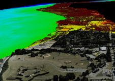
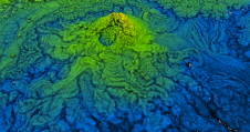
Key stakeholders including the NOAA Office for Coastal Management and NV5 Geospatial created a topobathymetric elevation model of Morro Bay in California as input for environmental conservation. Morro Bay, a shallow...

Vasily Lukashov is the founder & CEO of FIXAR. He is an engineer, developer and innovator of unmanned aerial solutions with deep roots in the industry since a young age....

Morteza Esfandiari, MSc, is a geospatial technician with McElhanney Ltd. Morteza received his MSc in Geodesy and Geomatics Engineering from the University of New Brunswick in 2021. His research interests...

Read this guide to the main 3D data representation methods to understand the key differences and choose the best method for your specific applications. The 3D data jungle in today’s...
Abdul Nurunnabi is a researcher at the Department of Geodesy and Geospatial Engineering, University of Luxembourg, Luxembourg. He gained his PhD in Spatial Sciences from Curtin University, Australia, with a...
These inspiring articles all prove the versatility of the brilliant technology that is Lidar. Sensor miniaturization has made Lidar technology easier to integrate, enabling applications such as UAV-based and handheld...

Advanced Navigation has acquired Vai Photonics, a spin-out from the Australian National University (ANU) developing patented photonic sensors for precision navigation. Advanced Navigation is one of the world’s most ambitious...
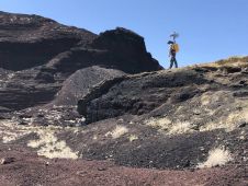
NASA researchers and their industry partners have developed a remote sensing mapping system to aid explorers in the most isolated wilderness imaginable: the airless wastes at the South Pole of...
This site uses cookies. By continuing to use this website, you agree to our Cookies Policy. Agree