New ScanMagic v.2.0
ScanEx R&D Center (Russia) has released version 2.0 of ScanMagic software, designed for Earth remote sensing data processing. The updated version supports popular cartographic services of Google, Microsoft and Yahoo....
ScanEx R&D Center (Russia) has released version 2.0 of ScanMagic software, designed for Earth remote sensing data processing. The updated version supports popular cartographic services of Google, Microsoft and Yahoo....
Leica Geosystems (Swizerland) has released Leica MobileMatriX version 2.0; a multi-sensors GIS solution for capturing GIS data directly in the field. The new version 2.0 now supports Leica ATX1230 GG...
Leica SpiderWeb version 2.0 has been extended with additional features and services that improve the usability and efficiency for both service users and service providers. Leica SpiderWeb is easy to...
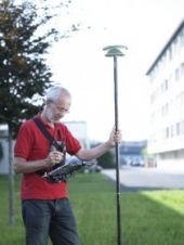
Version 2.0 of Leica GeoMoS has been released. This is a solution for multi-sensor structural monitoring using a range of high precision geodetic instruments from Leica Geosystems and third-party sensors....
DM Solutions Group (Canada) has made available Chameleon version 2.0, an Open Source software for creating customisable Web mapping applications. This latest version provides the flexibility to utilise both remote...

Planet was founded with the mission to image the Earth every day and make change visible, accessible, and actionable. Over the past decade with our customers, Planet has revolutionized the...
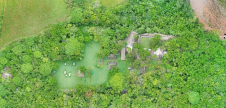
While it is possible to capture ancient Maya sites hidden beneath jungle canopy in remote locations using airborne Lidar, identifying them is still a time-consuming process. Typically, 3D point clouds...

A man who received a 360-degree camera as a gift has taken it upon himself to incorporate his neighbourhood in Guernsey into the Google Street View online map, according to...
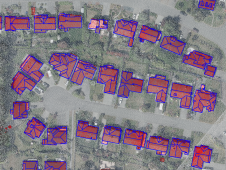
How can artificial intelligence and deep learning lead to a robust process for 3D city modelling? And what are some of the challenges? Automated classification and object detection in Lidar...
Dr Ferdinand Vettermann holds a PhD in Geoinformatics and is a cognitive solutions engineer at the German geointelligence company Deeeper.technology. As an expert in geoinformatics, he is responsible for linking...
This site uses cookies. By continuing to use this website, you agree to our Cookies Policy. Agree