Establishing an Operational SBAS Down Under
The Australasian region took a major step towards gaining its first-ever satellite-based augmentation system (SBAS) in early 2017. That is when the governments of Australia and New Zealand agreed to...
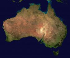
The Australasian region took a major step towards gaining its first-ever satellite-based augmentation system (SBAS) in early 2017. That is when the governments of Australia and New Zealand agreed to...

As France’s top rugby players scrum, run and tackle they are being tracked by more than just TV cameras and the watching eyes of the crowd. Satnav-based tracking devices between...

The Horizon 2020-funded PRoPART project successfully tested a Galileo-based positioning solution enhanced with Real Time Kinematic (RTK) technique for automated trucks and advanced driver assistance systems at the AstaZero Proving...
Septentrio, a leading manufacturer of accurate and reliable GPS technology, has released a key upgrade for their GPS post-processing software. Both GeoTagZ and PP-SDK now feature BaseFinder, a tool that speeds up survey workflow...

Researchers have received a H2020 grant to further improve the availability of the Galileo system and to integrate land surveys in the cadastral workflow. With this new European global navigation...

There are more than five billion satnav devices on Earth. Along with smartphones and mobile receivers, this figure includes networks of continuously operating receiver stations (CORS) used to improve accuracy....

Satellite-delivered GNSS correction services can be used in many real-time applications where real-time kinematic (RTK) and virtual reference stations (VRS) are not available. In areas without regular communication systems, satellite-broadcast...
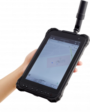
CHC Navigation has announced the availability of the LT700H RTK Android tablet designed to increase the efficiency and productivity of a mobile field workforce in any applications requiring centimetre to...

As of today, there are more than five billion satnav devices on Earth. Along with smartphones and mobile receivers, this figure includes networks of fixed receiver stations, used to improve...
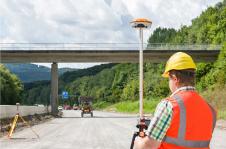
Satellite surveying… are there any industry professionals out there not using it on (almost) a daily basis? Over the last 30 years, GNSS has become the main positioning instrument for...
This site uses cookies. By continuing to use this website, you agree to our Cookies Policy. Agree