Transformative trends in laser scanning
In this Q&A, we asked Trimble’s Jeff Turgeon to share his insights into the current state of the sector and his expectations for the future. Looking at terrestrial laser scanners,...
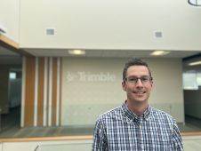
In this Q&A, we asked Trimble’s Jeff Turgeon to share his insights into the current state of the sector and his expectations for the future. Looking at terrestrial laser scanners,...

Arkadiusz Szadkowski is senior business development manager of reality mapping, imagery & remote sensing at Esri. He is passionate about leading the change towards 3D GIS and bridging the gap...

Both vertical and oblique aerial images have their own advantages, making them valuable in different reality mapping applications. So how can you choose between the two? This comparison will help...

In the rapidly evolving landscape of geospatial technology, the annual Trimble Dimensions gathering is a dependable beacon for the surveying and mapping fields, providing a panoramic view of the current...

Intergeo 2023 was an electrifying three-day event in Berlin, transforming the city into the global geospatial capital. From 10-12 October, professionals from across the globe convened for the world’s premier...

In this article, we examine the evolving landscape of bathymetry with insights from Anders Ekelund, vice president of airborne bathymetric Lidar at Hexagon Geosystems. Beyond mapping seagrass, Ekelund unveils Lidar’s...
How can city digital twins support the attainment of SDG11? They can be used to manage infrastructures (e.g. roads, transportation and public services, smarter energy grids and water networks), support...

The organizers of Geo Week have released a preview of two keynote sessions for 2024: 'The Bright Future Ahead: Navigating AEC, 3D, and Geospatial Innovation and Change', and 'Geospatial for...
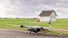
The new state-of-the-art Phase One P5 128MP camera has been seamlessly integrated into Quantum Systems’ flagship Trinity Pro mapping drone and the leading surveying workflow, Trimble Business Center. The resulting purpose-built,...

Harxon demonstrated its dedication to innovation at Intergeo 2023 by introducing two products designed to advance high-accuracy positioning within the geospatial industry: the Survey GNSS Antenna (HX-CSX600A) and the Helix...
This site uses cookies. By continuing to use this website, you agree to our Cookies Policy. Agree