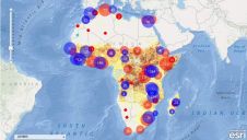
GIS to Better Target Aid
The Strauss Center's Climate Change and African Political Stability (CCAPS, TX, USA) programme has implemented Esri technology to view how climate change impacts vulnerable populations in Africa. CCAPS created the...
The Strauss Center's Climate Change and African Political Stability (CCAPS, TX, USA) programme has implemented Esri technology to view how climate change impacts vulnerable populations in Africa. CCAPS created the...

The Intergeo 2011 event has shown that there are many new things in the pipeline. GIM International caught up with Olaf Freier, managing director of HINTE GmbH and Intergeo organiser,...

Recently unveiled by Vexcel Imaging, the groundbreaking UltraCam Dragon 4.1 represents one of the market's most advanced, progressively designed and seamlessly integrated hybrid aerial mapping systems. Tailored for high-resolution mapping...
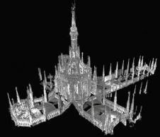
A highly accurate, 3D model is to support restoration work at the world's fourth largest church Duomo di Milano or Milan Cathedral in Italy. Millions of laser-scanned measurements were combined...
Many of the applications and services used by public authorities and institutions will be on display at INTERGEO in Karlsruhe (Germany) from 22th to 24th September 2009. The world trade...

Having been active in the geospatial industry for over 20 years, Hi-Target has gained a strong reputation in the global market and established a network of 64 subsidiaries, 28 branches...

RIEGL has recently added the VUX-18024, a lightweight and versatile UAV-Lidar sensor for high-speed surveying missions, to its portfolio. This once again underlines the Austrian company’s pioneering role as a...
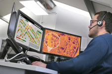
Geosoft (Canada) has made available its 2008 Target for ArcGIS software release, version 3.0. The new 3D capabilities in this release enable customers to enhance their view of the subsurface,...
Using a high-tech thermal imaging camera to measure heat loss from roofs, aerial mapping company Bluesky International is helping to identify poorly insulated homes and other public buildings. The property...
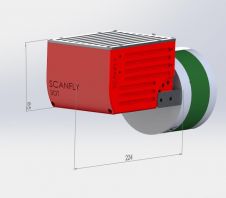
3D Target, an Italian manufacturer of measurement instruments, is launching a new Scanfly product. Scanfly is a turnkey solution for 3D Lidar mapping, specifically designed for unmanned aerial systems (UASs)....
This site uses cookies. By continuing to use this website, you agree to our Cookies Policy. Agree