Assessing environmental changes with GNSS reflectometry
An innovative geodetic tool called GNSS-IR is a more effective technique than tide gauge for monitoring sea surface height as the basis for modelling sea level variations, according to the...

An innovative geodetic tool called GNSS-IR is a more effective technique than tide gauge for monitoring sea surface height as the basis for modelling sea level variations, according to the...

Septentrio’s collaboration with major drone solutions providers is driving new products allowing easier prototyping or integration of its Mosaic GNSS receiver into uncrewed aerial vehicles (UAVs or ‘drones’). The companies...

One day before the start of Intergeo 2012, IGI, based in Germany, hold its successful User Meeting, attracting participants from around the globe. Delegates were provided with the opportunity to...
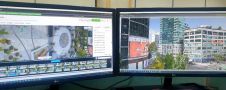
IGI mbH (Germany) has updated its software solution for the management and analysis of precision measurements for the aerial survey industry. AEROoffice v5.1 calculates the exact real world position and...
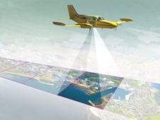
SaeHan Aero Survey has become the first customer in Korea to purchase the IGI UrbanMapper-2P. This nadir and oblique imaging system will be operated together with IGI’s LM-7802S, a high-performing...
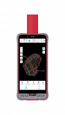
ComNav Technology has introduced its new handheld P6H. This advanced and rugged device is tailor-made for GIS data collection and outdoor operations. Featuring a GNSS high-precision positioning module, rugged IP67-rated...
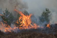
The number of wildfires has increased dramatically in recent years due to diminishing forest health caused by the drastically changing climate across the world. Longer dry-weather periods and pressure from a variety of pests and diseases, e.g. bark beetles, are affecting the large forest areas in Northern Europe. In addition to financial losses, these impacts are resulting in lower carbon accumulation and vast ecological changes. The number of wildfires has increased dramatically in recent years due to diminishing forest health caused by the drastically changing climate across the world. Longer dry-weather periods and pressure from...

IGI, manufacturer of mobile mapping systems, aerial cameras and other turn-key geospatial solutions, has become official sponsor of the 3D Modelling and Visualization Weeks organized by 'GIM International'. The online...
This site uses cookies. By continuing to use this website, you agree to our Cookies Policy. Agree