Navcom Expands Starfire System
NavCom Technology (CA, USA) has released new software for its RTK and StarFire products providing users access to an expanded StarFire Network of six satellites and NavCom's new Ultra RTKä...
NavCom Technology (CA, USA) has released new software for its RTK and StarFire products providing users access to an expanded StarFire Network of six satellites and NavCom's new Ultra RTKä...
Tele Atlas (MA, USA) has unveiled Tele Atlas MultiNav, the company's newest digital map platform that is designed to allow navigation application developers even greater speed and flexibility for building...
OnPoz Precision Positioning has introduced of a new version of its EZSurv GNSS post-processing software, introducing advanced post-processing automation capabilities. The new version of the software includes extensive support for...

TThe GRS-1 has obtained TÜV certification under the European Union (EU) Agricultural Directive Commission Regulation 796/2004, Article 30. This directive supports the validation of area measurement methods for agricultural land...
NavCom and Astrium Services have formed a strategic partnership to deliver precise positioning solutions throughout Europe. Through this alliance, Astrium Services will become the sole European supplier of NavCom's GNSS...
With the advent of navigation technology, getting lost has become a thing of the past. It was not so long ago that navigation systems were considered rather expensive gadgets offering...

NavCom Technology has released the SF-3050 multi-frequency GNSS receiver with its new Sapphire GNSS OEM board. Offering integrated StarFire/RTK GNSS capabilities, the SF-3050 and Sapphire feature 66-channel tracking, including multi-constellation...
A group of Saudi Arabian and European partners have completed a project to implement and provide satellite based environmental information products and services to the Presidency of Meteorology and Environment...
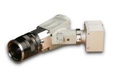
Specim, Spectral Imaging is launching a high-resolution hyperspectral imaging sensor with exceptional performance and the dimensions required for Unmanned Aerial Vehicles (UAV) and other challenging applications. The V10M sensor operates...

MGGP Aero has realised a new Airborne Photogrammetric Platform, being an integration of the Cessna T206H NAV III with the LiteMapper 6800i. Aircraft made its maiden flight across the Atlantic...
This site uses cookies. By continuing to use this website, you agree to our Cookies Policy. Agree