Found 6738 results
Sort by

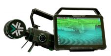
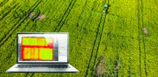
Pix4D Unveils New Precision Agriculture Solutions

Pix4D has launched Pix4Dmapper Ag: photogrammetric software that converts multispectral images into agriculture-specific maps for better crop management and analysis. The software has been released in conjunction with Sequoia: a multispectral sensor...

Read more

Pix4D Platinum Sponsor of UAV-g 2013

Pix4D, Switzerland, has announced it will be platinum sponsor of UAV-g 2013. This year's UAV-g will be held at Rostock University, Germany, from 4 to 6 September. The conference focuses...

Read more

Rethinking service in the surveying industry

Looking for a recipe for business success in surveying? Don't underestimate the importance of innovative surveying services, says Moritz Lauwiner. The latest measurement sensors and software, decades of collective experience...

Read more