Berlin gears up for geospatial excellence
As the host city of Intergeo 2023 this October, Berlin promises to deliver the perfect kick-start for the geospatial industry in these rapidly changing times. The vibrant German capital is...

As the host city of Intergeo 2023 this October, Berlin promises to deliver the perfect kick-start for the geospatial industry in these rapidly changing times. The vibrant German capital is...
Although the essence of surveying has barely changed since the profession began, the increasingly complex digital continuum requires geospatial professionals to adapt their skills in dynamic and important ways, writes...
Advanced Navigation has unveiled an expansion of its Boreas digital fibre-optic gyroscope (DFOG) range with the introduction of the new A Series. This development showcases the company’s commitment to meeting...

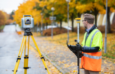
The University of Bradford has taken delivery of the UK’s first Leica TRK700 Evo – a vehicle-mounted mobile mapping system capable of capturing two million data points every second to...

To encourage discussion of the challenges hindering the design and implementation of digital twins, the authors have ranked them based on a systematic literature review combined with an expert survey....
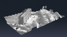
A new partnership marks a significant milestone in the field of reality capture: NavVis has selected Hesai as its exclusive Lidar sensor provider for its industry-leading device, the NavVis VLX...
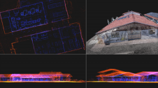
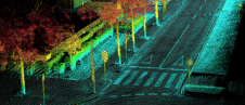
Since the explosion of Lidar over the past two decades, the use of point clouds in aerial mapping applications has become common these days. However, Lidar is not without its challenges. This article explores how colourized point clouds from photogrammetry can offer a value-adding alternative. Since the explosion of Lidar over the past two decades, the use of point clouds in aerial mapping applications has become common these days. However, Lidar is not without its...
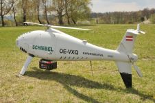
RIEGL Laser Measurement Systems and Schiebel have successfully completed the integration of a high-end laser scanning system, the RIEGL VQ-840-G topobathymetric Lidar sensor, on the Schiebel Camcopter S-100 uncrewed aerial...
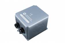
Ordnance Survey, the national mapping agency for Great Britain, was in need of a faster and more cost-effective way to collect georeferenced point cloud data, because the existing method was not sustainable in the long term. The Ordnance Survey team turned to Datron Technology and OxTS to help them develop a convenient, low-cost, ‘off-the-shelf’ mobile mapping system. Ordnance Survey, the national mapping agency for Great Britain, was in need of a faster and more cost-effective way to collect georeferenced point cloud data, because the existing method was...
The Locator One solution for autonomous GNSS-based precision measuring has been sold and leased to numerous construction and infrastructure companies, both in the Netherlands and internationally. It was jointly developed...
This site uses cookies. By continuing to use this website, you agree to our Cookies Policy. Agree