GEO Business 2019 Opens Registration
GEO Business, geospatial exhibition and conference, has announced that registration is now open! With more exhibition space than ever before, GEO Business 2019 is on track to be another record-breaking...

GEO Business, geospatial exhibition and conference, has announced that registration is now open! With more exhibition space than ever before, GEO Business 2019 is on track to be another record-breaking...

Today’s digital societies require a continuous supply of updated, reliable and correct geodata, and new technologies are arriving with increasing speed. The manned aerial survey is by far the main...

Lidar technology is more present in our lives than we realize – and sometimes even while we watch television, for instance. Imaging hardware and software from Teledyne Optech helped to...
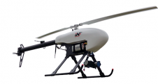
LiDARUSA, a leading company in the design and integration of Lidar sensors, has announced a partnership with Innoflight Technology, a manufacturer specializing in unmanned aerial vehicle (UAV or 'drone') systems...

Delegates from around the world flocked to the first European Association of Aerial Surveying Industries (EAASI) Summit. Attracted by a topical conference programme, working group sessions and a variety of...
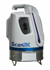
Carlson Software has released its Scan2K laser scanner, a versatile and user-friendly solution for the creation of accurate 3D survey data up to a range of 2,000 ('2k') metres. The...
Andy Hoggarth’s role at the helm of BD at CARIS is to understand trends in the business space industry as it evolves and to translate these from idea to product....
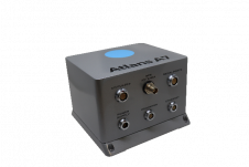
OGI has selected iXblue’s Atlans FOG-based inertial navigation system for its new mobile mapping Lidar solution dedicated to road assessment surveys. OGI, Oceanographic & Geophysical Instruments has selected iXblue’s Atlans...
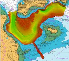
Various multibeam Lidar sensors are suited for mobile mapping. Read this article to learn more about their features and productivity. In mobile mapping, geospatial data is acquired by one or...
Lidar technology is synonymous with 3D point clouds. To get the most out of 3D point cloud data, it is necessary to step back and continually consider the newest trends...
This site uses cookies. By continuing to use this website, you agree to our Cookies Policy. Agree