From paper to pixels in Benin
To provide all Beninese citizens the right to access land, bring economic prosperity and prevent land-related disputes, the Beninese government aims to establish a nationwide digital land administration system. With...

To provide all Beninese citizens the right to access land, bring economic prosperity and prevent land-related disputes, the Beninese government aims to establish a nationwide digital land administration system. With...

GeoMax, a leading provider of quality construction and surveying instruments and software, has appointed Phil Jarratt to take the lead for training & support in the UK and Ireland. Phil...

Intermap Technologies, a global leader in 3D geospatial products and intelligence solutions, has been contracted to provide its high-resolution NEXTMap elevation data and precision radar imagery to support the United...
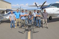
Condor Aviation, a partnership between the Yurok Tribe’s Fisheries Department and the Yurok Tribe Construction Corporation, acquired a RIEGL Lidar sensor to collect data that will inform natural resource management...

The Academy of Model Aeronautics (AMA), DJI, and Fly-Robotics will be presenting a public safety training workshop as part of the pre-conference offerings at Drone World Expo 2017, taking place...
Which factors contribute to the slow adoption of TLS in Nigeria? These insights can help to stimulate the uptake of instrumentation and enhance professional surveying in other developing countries across...
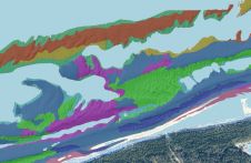
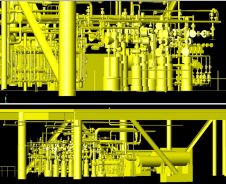
This article presents a novel methodological approach to understand and assess the suitability of airborne Lidar bathymetry for the automatic classification and mapping of the seabed. This solution allows recording of...

From 5-9 June, ComNav Technology's Annual Partner Conference 2023 took place in Shanghai, China. Some 30 global distributors from the UK, Japan, Australia, Guyana, Uganda and other countries gathered to...

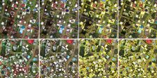
In collaboration with AI Singapore, the Singapore Land Authority (SLA) has launched an innovative challenge centered on visual localization, aimed at addressing how AI can accurately extract camera pose data...
From drones and satellites to airborne-based sensors and Lidar, advances in remote sensing and geospatial information science are driving the development of innovative methods for data acquisition, processing and maintenance....
This site uses cookies. By continuing to use this website, you agree to our Cookies Policy. Agree