Mapping a Landslide Using UAS
An Unmanned Aerial System (UAS) was used to acquire images of a small area in Italy for the purpose of post-landslide monitoring. The entire chain from aerial survey up to...
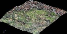
An Unmanned Aerial System (UAS) was used to acquire images of a small area in Italy for the purpose of post-landslide monitoring. The entire chain from aerial survey up to...

COWI, headquartered in Denmark, has been authorised to use unmanned aircraft systems (UAS) for commercial purposes. The company believes that this will make airborne mapping of small geographical areas, recording...

C-Astral, Slovenia, has made a series of presentations of its Bramor UAS family and has introduced the new Bramor EO/IR/LI line. The new model has doubled flight endurance and is...

When ownership of one or more parts of a parcel changes, seller(s) and buyer(s) are legally obliged to identify the new boundaries. Stakeholders are often unable to attend the on-site...

Which factors secure the success of an emergent technology? After years of toil within a university or laboratory, researchers realise that their findings have market potential. Co-operation with a commercial...

Since 2011, the use of Unmanned Aerial Systems (UAS) as complementary surveying devices has mushroomed. With resolutions as high as 1cm, the resulting imagery enables the highly automated production of...

Dr Lomme Devriendt, head of the Department of Photogrammetry at Orbit Geospatial Technologies, will speak at the UAS Event on 11 April 2013. He will discuss UAS mapping as an...

As you may have noticed, GIM International has been publishing a series of articles on UAS and its use in geomatics in recent months. We know that these articles are...
Woolpert, an American geospatial, infrastructure management and design consulting firm, has purchased its first UAS, the Nova Block III, from partnering UAS firm Altavian. The Nova Block III is an...

With the rise of Terrestrial Laser Scanning a decade ago and more recently Unmanned Aerial Systems (UAS), which are also called drones, the differences between how geodata is obtained by...
This site uses cookies. By continuing to use this website, you agree to our Cookies Policy. Agree