Leonardo Ercolin Filho
Leonardo Ercolin Filho holds an MSc in transportation engineering (2009) and a PhD in geodetic sciences (2017). He is adjunct professor at the Federal University of Paraná, Brazil, and his...

Leonardo Ercolin Filho holds an MSc in transportation engineering (2009) and a PhD in geodetic sciences (2017). He is adjunct professor at the Federal University of Paraná, Brazil, and his...

A pilot project conducted at a university campus in Curitiba, Brazil, aimed to create outdoor maps using UAS photogrammetry as well as indoor floor plans. At universities, facility managers and...

The battle against poverty in developing countries has always been associated with the issue of land. Since the turn of the millennium, the focus has been on facilitating the official...

Iris Automation, an artificial intelligence (AI) and safety avionics company, has announced the launch of Casia – the first commercially available computer vision detect-and-avoid solution to enable Beyond Visual Line...
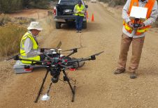
Archaeologists have been studying the Sand Canyon Pueblo in Colorado, USA, for decades. Today, painstaking traditional mapping and visualizations no longer suffice for detailed studies. A survey combining an unmanned...

Amsterdam Drone Week and Diversified Communications, the global organizer of Commercial UAV Expo Europe, are joining forces to host a combined trade show and conference focusing on unmanned aerial vehicles...
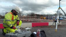
The international infrastructure group Balfour Beatty is reaping the rewards of using drones on major construction projects, including work on a multi-million-pound 'Smart Motorway' upgrade in the Midlands region of...

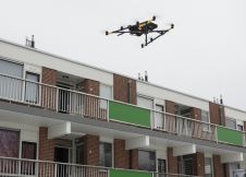
DPR Construction has signed an enterprise-wide agreement with Skycatch creating a new model of unmanned aerial vehicle (UAV) standardization and productivity available for all of their project sites. In construction,...
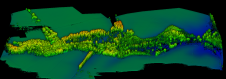
Wetlands are essential ecosystems which provide numerous benefits to society as a whole. But their functionality strongly depends on the hydrology and topography of the watershed, thus creating the need...
Could drones form the missing link between aerial imaging and terrestrial data capture? Aeroscan's Mark Nicolai believes so, as he explains in this interview. There have been rapid advancements in...
This site uses cookies. By continuing to use this website, you agree to our Cookies Policy. Agree