Special Edition of GIM International on UAS
As you may have noticed, GIM International has been publishing a series of articles on UAS and its use in geomatics in recent months. We know that these articles are...

As you may have noticed, GIM International has been publishing a series of articles on UAS and its use in geomatics in recent months. We know that these articles are...

Since 2011, the use of Unmanned Aerial Systems (UAS) as complementary surveying devices has mushroomed. With resolutions as high as 1cm, the resulting imagery enables the highly automated production of...

C-Astral, Slovenia, has made a series of presentations of its Bramor UAS family and has introduced the new Bramor EO/IR/LI line. The new model has doubled flight endurance and is...
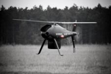
Schiebel and RIEGL, Austria, have successfully integrated the CAMCOPTER S-100 unmanned air system with the VQ-820-GU hydrographic airborne sensor. The integration marked the first time that the new airborne sensor...

One of the elements that makes Intergeo particularly dynamic is the so-called Trend and Media Forum. The Forum, based on the exhibition floor, functions as a platform for companies, giving...
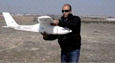
At UVEX 12 in Madrid, Spain, MAVinci's Spanish UAS distributor Grupo Acre presented SIRIUS I, a UAS for civil applications and specialised for orthophotos and mapping. Before being allowed to...

Drones have become a standard tool for mapping and surveying. Read what Gilles Labossière, CEO of senseFly, has to say about the market trends, technical developments and challenges affecting geospatial professionals. Even...
Leveraging UAS technology across surveying and engineering sectors is demanding. Meeting the expectations of accuracy and accountability requires the best in expertise, methodology and equipment. The latest unmanned aerial system...
Archaeologists have been studying the Sand Canyon Pueblo in Colorado, USA, for decades. Today, painstaking traditional mapping and visualizations no longer suffice for detailed studies. A survey combining an unmanned...
This site uses cookies. By continuing to use this website, you agree to our Cookies Policy. Agree