Found 1357 results
Sort by

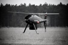
Bluesky Launches Unmanned Aerial Vehicle

UK-headquartered aerial survey company Bluesky has launched a fast response aerial survey service using unmanned aerial vehicles (UAV) or drones. The technology, originally developed by the military, includes Artificial Intelligence...

Read more

INS for Airborne Mapping

iXBlue, France, has presented ATLANS as a cost-effective georeferencing and orientation system, designed for land and airborne mapping applications. The user obtains a compact, lightweight gyrocompass and motion sensor that...

Read more

Conservation Drones

Global land-use changes continue to be a major driver of biodiversity loss and greenhouse gas emissions, and remote sensing technology is increasingly being used to assess changes in land use,...

Read more

Quadcopter Manufacturer Invests in Pix4D

Pix4D, Switzerland, has agreed on a CHF2.4 million investment from the Parrot Group to accelerate the development of its successful Mapping and Geographical Information System (GIS) software for Unmanned Aerial...

Read more