NEST 2C Available for Free
NEST (Next ESA SAR Toolbox) is an ESA toolbox with an integrated viewer for reading, post-processing and analysing ESA and 3rd party SAR data starting from Level 1. Distributed as...
NEST (Next ESA SAR Toolbox) is an ESA toolbox with an integrated viewer for reading, post-processing and analysing ESA and 3rd party SAR data starting from Level 1. Distributed as...

From last June, the ScanEx Research and Development Center takes part in the international project Global Land Survey 2010. The GLS Program is aimed at building global satellite Earth coverage...
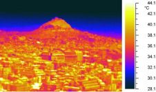
In a series of coordinated activities, called Thermopolis 2009, a group of thermal remote-sensing and urban-climate experts from Greece and Spain carried out ground-based measurements at various sites in and...
Surrey Satellite Technology Limited (SSTL) has restructured its business, forming two new business units to manage continuing growth in its Earth Observation and Science and Telecommunications missions. The Telecommunications and...
To exploit the full potential of Lidar data, three-dimensional (3D) spatial indexing capabilities are required in vendor systems. Multiple software packages are currently needed, which entails importing and exporting different...

The Topcon DL-500 implements ‘Wave-and-Read' technology, providing an additional survey style option that allows a rod person to wave the staff back and forth, instead of keeping the staff plumb....

Yehliu Geopark selects SuperGIS Mobile Tour 3 developed by SuperGeo Technologies to establish an electronic tour guide system. This system is deployed to lots of handheld devices for visitors' use...
Make data accessible! Ed Parsons, Google's geospatial technologist for Europe, Middle East and Africa was shedding light on the future of the geospatial business during his keynote speech to the...

Management of the relationship between land and people has always been complex and sensitive. Land is part of the social and political framework that sustains communities around the world. It...
Ideas shape business. Sometimes it's good to realise that all applications and software packages found in the field of land registration and cadastre have their basis in ideas about how...
This site uses cookies. By continuing to use this website, you agree to our Cookies Policy. Agree