Monitoring Coastal Erosion with UAV Lidar
This survey in southern France confirmed the suitability of UAV Lidar for mapping shoreline changes in the context of erosion and drinking water availability. The French Mediterranean coast is a...
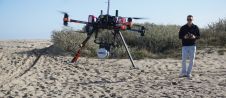
This survey in southern France confirmed the suitability of UAV Lidar for mapping shoreline changes in the context of erosion and drinking water availability. The French Mediterranean coast is a...
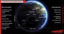
The Earth Observation (EO) industry is going through a time of radical and exciting transformation. No longer exclusively the realm of government and big industry, space is becoming increasingly accessible...

At some time in their lives, everyone has experienced a situation in which someone starts telling them a story that seems to be leading somewhere really interesting, and then all...

At a time when satellite imagery is in abundance, it is important for geospatialists to have a deeper understanding of the data which they are working with. In the following...
The International Association of Forensic and Security Metrology (IAFSM) held its 2017 gathering in Atlanta, Georgia (nicknamed Y’allywood because so many television shows and films are now being made there)....
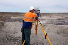
What is the current status of surveying in the mining industry, and which types of survey equipment and technologies are being used today? Geospatial data forms the foundation of mining....

LocationTech, an Eclipse Foundation Working Group and a community that builds software for geospatial technology, has announced the release of five open source projects that provide core technology used to...
The Open Geospatial Consortium (OGC) is seeking public comment on its candidate CDB Multi-spectral Imagery Extension standard. The Multi-spectral Imagery Extension defines how to encode and store reflected electromagnetic radiation...

The world’s leading fair and conference on geodesy, geoinformation and land management, recently took place in Berlin and provided an open global environment for the geo-information community and geomatics technology...

Intergeo 2017, the world’s leading fair and conference on geodesy, geoinformation and land management, recently took place in Berlin and provided an open global environment for the geoinformation community and...
This site uses cookies. By continuing to use this website, you agree to our Cookies Policy. Agree