ZZCOMM Technology Co Ltd
Founded in 2017, ZZCOMM technology of geospatial hardware and software solutions provides rapid and high-accurate geospatial data for BIM, mining AEC, survey and mapping industries, whether they are indoor, outdoor,...

Founded in 2017, ZZCOMM technology of geospatial hardware and software solutions provides rapid and high-accurate geospatial data for BIM, mining AEC, survey and mapping industries, whether they are indoor, outdoor,...

From the skies to the ground, aerial surveying and mapping professionals play a crucial role in capturing, processing, analysing and publishing geospatial data. This article explores the diverse career opportunities...
FalconScan, based in Maryland, USA, has recently announced the release of its aerial mapping system. Features include flight planning, guidance and data capture software, a spectrally calibrated digital high-spatial-resolution camera...
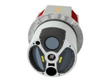
ClearSkies Geomatics, based in Colorado, USA, has recently added the RIEGL VQ-1560 II-S airborne laser scanner to its growing rental system fleet. This laser scanner, an advancement of RIEGL's dual-channel...

Calling all professionals! Please contribute to the 2024 edition of the annual geospatial industry survey by GIM International, which is currently in progress. This yearly tradition serves as a valuable...
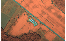
Woolpert has secured a contract with the University of Wyoming to generate a digital terrain model and contours. Leveraging Lidar data previously acquired for the United States Geological Survey (USGS),...

1Spatial has successfully secured a three-year contract with a leading distribution system operator for electricity and gas networks in Belgium. The contract, awarded after a competitive tender process, will involve...

Global reference systems such as the International Terrestrial Reference Frame provide the foundation for determining positions on Earth and in space, as well as for reliably quantifying our planet’s changes...

South African GeoM (formerly Geomatica) has invested in a navigation system designed to improve the locational accuracy and reliability of aerial survey data. The purchase of a 5th-generation Computer Controlled...

Trimble (USA) has introduced its Unmanned Aircraft System (UAS): the Trimble UX5 aerial imaging rover with the Trimble Access aerial imaging application. The solution builds upon its predecessor, the Trimble...
This site uses cookies. By continuing to use this website, you agree to our Cookies Policy. Agree