Lidaretto
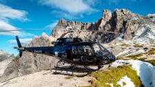
Lidaretto is flexible and compact Lidar scanning system developed since 2015 and uniquely designed to be used the way that fits best to users’ specific application. You can easily mount...

Lidaretto is flexible and compact Lidar scanning system developed since 2015 and uniquely designed to be used the way that fits best to users’ specific application. You can easily mount...
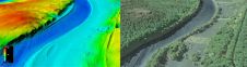
The US Geological Survey (USGS) and Dewberry have jointly released a new topobathymetric Lidar dataset for the Potomac River, extending from the Potomac Highlands in West Virginia to the Chesapeake...
NZ Aerial Mapping Limited (NZAM) has been awarded the contract for the renewal of the 150 markers of the Partitioned Zone, its Dividing Line and the Boundary Line between The...

The Norwegian Polar Institute would like tenders for aerial photography on Svalbard by a digital high resolution aerial camera. GPS/INS shall be used for geo-references. Bidding Type International Competitive Bidding...
As of 1st January 2008, and after more than eight years as part of Fugro-Inpark BV, the Aerial Acquisition division (better known as FLI-MAP) is continuing life as a separate...
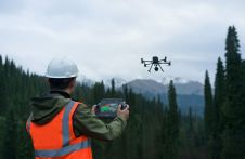
Developing countries still have a need for mapping systems that are low-cost, simple to operate by local operators, fast in production and yet meet the needs of the application. A...
The Irish Department for Agriculture, Food and the Marine (DAFM) has awarded Getmapping a contract to supply new high-resolution aerial photography and digital height models for the Republic of Ireland....
DJI selected Intergeo in Berlin as the stage for unveiling the DJI Zenmuse L2. This highly integrated Lidar system builds on the success of DJI’s Zenmuse L1 to bring new...
Hexagon, a global leader in sensor, software and autonomous solutions, has announced the signing of an agreement to acquire COWI's aerial mapping business. COWI, based in Denmark, is a leading...
Gravitational acceleration measurements were conducted in the Allgäu region of southern Germany by the Federal Agency for Cartography and Geodesy (BKG) in September this year. In high-altitude locations, helicopters were...
This site uses cookies. By continuing to use this website, you agree to our Cookies Policy. Agree