Lidar Data – A Perfect Tool for Archaeology
A few obstacles are making the usage of Lidar data in archaeology look exotic and perhaps even threatening, according to archaeologist Jošt Hobič from Slovenia, even though Lidar is almost...

A few obstacles are making the usage of Lidar data in archaeology look exotic and perhaps even threatening, according to archaeologist Jošt Hobič from Slovenia, even though Lidar is almost...
Why is unsupervised segmentation the key to sustainable automation? Automation in point cloud data processing is central for building efficient decision-making systems and to cut labour costs. The identification of...
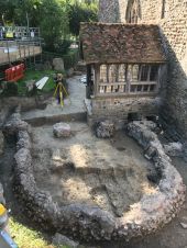
The church of St Mary and St Ethelburga is situated in Lyminge, a village rich with Anglo-Saxon history in Kent, England. The building and surrounding churchyard have seen many changes...
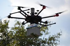
Lidar mapping based on unmanned aerial vehicles (UAVs or ‘drones’) can generally be thought of as a close-range version of manned airborne laser scanning. In brief, lower mobilization costs and...

How can modern geospatial technology be used to preserve the past? Archaeology students from Wheaton College in Illinois, USA, have utilized a long-range Lidar sensor during an excavation project in...
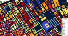
Colouring London is a crowdsourcing initiative to create a coloured map which visualizes the rich details of the built environment. The project can also be transferred to other cities. Colouring...
A detailed laser mapped aerial survey from Bluesky is helping the City of London Corporation understand and plan for the future of London’s most extensive, natural grassland. The historic environment...
Teledyne Optech, a Teledyne Technologies company and global leader in advanced Lidar sensors, has announced that its new compact Lidar sensor, the CL-90, is available for purchase through its first...
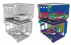
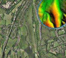
This issue of GIM International has a special focus on Lidar technology, with applications ranging from agriculture to archaeology. The front cover image shows very detailed 3D Lidar data that accurately depicts...
Over the past decade, Geosud has contributed to successfully mitigating the various obstacles to the operational use of satellite imagery for environmental management and territorial development. Geosud’s role in the...
This site uses cookies. By continuing to use this website, you agree to our Cookies Policy. Agree