HP Expands with Acquisition of the Business of Scitex Vision
HP (CA, USA) has announced that it has signed an agreement to acquire substantially all of the assets of Scitex Vision, a market leader in super-wide digital printing, for US$...
HP (CA, USA) has announced that it has signed an agreement to acquire substantially all of the assets of Scitex Vision, a market leader in super-wide digital printing, for US$...

Prague recently served as the testing ground for the integration of Mosaic’s 360-degree camera system with SmartDelta’s mobile mapping software. Known for its rich history and stunning architecture, the city...
A global audience of geospatial professionals witnessed the presentation of the JOUAV VTOL Hangar, a groundbreaking development in the field of vertical take-off and landing (VTOL) drones, at Intergeo 2023....

Software developed by EarthSense Systems has been used to assess how trees impact on urban air quality on one of London’s most polluted streets. Called FluidAir, the state of the...
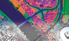
A pioneering project in Poland has proved that aerial mapping, combined with Lidar technology, can be an invaluable tool for accurately mapping the green urban environment. In fact, the new,...

Altus Positioning Systems, USA, has announced the availability of the new Juniper Archer 2 field computer packaged with Altus’ APS-3 GNSS RTK receiver. When paired with the performance, portability and...
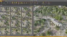
Virtual Surveyor has added drone photogrammetry capabilities to the latest release of its popular Virtual Surveyor smart drone surveying software. The new Terrain Creator app photogrammetrically processes drone photos to...

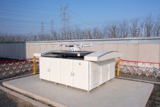
Mapbox has announced it will integrate its Vision SDK with Microsoft Azure IoT platform, enabling developers to build innovative applications and solutions for smart cities, the automotive industry, public safety...
Balko Tech has launched Connectiv, the next evolution of its modular drone Lidar system. This release also includes the introduction of the e-Connect application. Following the success of the e-ONE...

In a new partnership, Sanborn will use Pixxel’s hyperspectral dataset to equip its customers with advanced insights to solve problems as varied as agriculture crop and forestry health monitoring, exploration for...
This site uses cookies. By continuing to use this website, you agree to our Cookies Policy. Agree