New DJI Mavic 3 Enterprise Broadens UAV-based Mapping Possibilities
DJI has introduced its new DJI Mavic 3 Enterprise series designed to reimagine what drones can do for business, government, education and public safety. The DJI Mavic 3E and DJI...
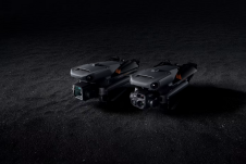
DJI has introduced its new DJI Mavic 3 Enterprise series designed to reimagine what drones can do for business, government, education and public safety. The DJI Mavic 3E and DJI...

Transforming the raw data gathered by Earth-observing instruments into actionable knowledge is a challenging task, especially when instruments have to decide for themselves which data points are most important. Engineers...
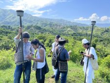
Local indigenous youngsters in northern Colombia have mapped the boundaries and sacred sites of their village, Gunmaku in the Sierra Nevada of Santa Marta, and the indigenous authorities are happy...

NavVis, the German provider of reality capture and digital factory solutions, is capturing BMW Group’s worldwide plants and making the photorealistic panoramic images, floor plans and point cloud data available...

Is the market influx of cheap UAV hardware and software making it difficult for surveyors and engineers to produce quality mapping? Is the industry heading for a race to the...
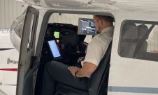
Woolpert has been selected to collect, process and deliver topographic mapping across more than one quarter of Nigeria, or roughly 258,000 square kilometres, under a US$4.4 million contract with the...
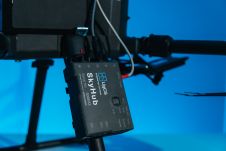
SPH Engineering has announced the third generation of the UgCS SkyHub hardware and released the largest update of the UgCS SkyHub software ever. The development accumulates five years of knowledge...

Maxar Technologies has announced its strategic investment in Blackshark.ai, a leading provider of AI-powered geospatial analytics services. Maxar is a provider of comprehensive space solutions and secure, precise geospatial intelligence....
Arrowhawk Imaging has selected an UltraCam Eagle Mark 3 aerial camera system with a 100mm lens as its first airborne imaging system. Since purchasing the sensor from Vexcel Imaging in...

How accurate is accurate enough? If you’re like most land surveyors, the answer is “as much as possible.” With an RTK drone, surveyors and other drone pilots can expect centimetre-level...
This site uses cookies. By continuing to use this website, you agree to our Cookies Policy. Agree